


The Kedartal Trek, Here are some of the most important highlights of this trek:
Kedartal Lake: The trek leads to Kedartal, a glacial lake situated at an altitude of 4,750 meters. The lake is surrounded by towering peaks, including Thalay Sagar and Bhrigupanth, and is known for its crystal-clear waters and stunning reflection of the surrounding mountains.
Gaumukh Glacier: The trek passes through the Gaumukh Glacier, the source of the holy Ganges River. The glacier is a sight to behold, with its pristine ice formations and stunning views of the surrounding mountains.
High Altitude Camping: The trek includes camping at high altitudes, providing an opportunity to experience the beauty and serenity of the Himalayas. The camping sites offer stunning views of the surrounding mountains, and the clear night skies are perfect for stargazing.
Gangotri Temple: The trek starts from the holy town of Gangotri, which is home to the famous Gangotri Temple. The temple is dedicated to the goddess Ganga and is an important pilgrimage site for Hindus.
Local Culture: The trek passes through several small villages, providing an opportunity to experience the local culture and interact with the friendly villagers. The villages are known for their traditional architecture and handicrafts, and the local cuisine is a highlight of the trek.
Overall, the Kedartal Trek is a wonderful opportunity to experience the natural beauty and cultural richness of Uttarakhand, and it is highly recommended for experienced trekkers who are up for a challenging adventure.
Should you trek to Kedartal or not, and do so because of it?
These treasures are worth thinking about, how beautiful and huge these treks are, when you go here you will find yourself, Kedartal trek which starts from Uttarkashi Gangotri Dham in Uttarakhand State,
The Kedaratal trek is a wonderful and natural tal, which is 17 kilometers from Gangotri, these Tal are in the middle of beautiful hills with an altitude of about 4,912 meters. For Kedartal, we need to travel only after getting a permit from the forest, these treks from Gangotri are about to climb, when we leave from Gangotri for the Bhojkharak camp, then the stepping starts from the one who feels very tired. Yes, but for those who are adventure lovers, they are nothing but adventure, at a distance of about 8 km from Gangotri, the route passes through the magnificent and difficult paths,
Even from Bhoj Kharak camp to Kedarkharak, today is a very good day, but today you will have to climb about 5 Km from near Grass and Kedarganga. If you are in luck, these camps are very beautiful from here and the mountain range starts to appear, from Kedarkharak to Kedartal are just 4 kilometers away which are very spectacular, you will feel happy after going here and here from here you will be able to see other mountain ranges close to Thalay Sagar 6,904 meters, Peak, Meru Peak 6,660 meters.etc
The climate and temperature here vary from time to time, so you should come with your preparation according to the time and the months, it can also be difficult to trek to without out local ,
This place is amidst the tall standing mountains all covered by snow, you will get the magnificent views of snow-covered mountains, you don’t often get the close view of mountains on many treks, but at Kedar Tal, you will get close and majestic views of them. Mountains like Thalay Sagar, Bhrigunath, Meru, and Mt. Gangotri and Manda Parvat are closely visible.
The trail goes through pine forest and the climb is steep, it is moderate to difficult trek as the climb is steep and there are landslide-prone areas and you have to go through them, it is an adventurous trek and not recommended for beginners but adventure lovers can choose this unique glacial lake trek.
About Base camp Kedartal at Gangotri
Gangotri is a starting point of Kedartal trek, Gangotri is a holy town perched at an altitude of 3,092 m on Bhagirathi River’s banks in Uttarkashi district. According to the legend, it is Goddess Ganga’s shrine and this pious site is the part of Chota Char Dham which holds a great place in the heart of Hindu mythology and Hindu devotees.
History and Significance:
Historical Significance: Gangotri Dham holds immense religious significance in Hinduism. It is believed to be the place where Goddess Ganga descended to Earth from heaven, following the prayers of King Bhagirath to cleanse the souls of his ancestors.
Mythological Legends: According to Hindu mythology, Goddess Ganga initially descended to Earth with such force that it would have flooded the entire Earth. Lord Shiva intervened by catching her in his locks, thereby reducing the impact of her descent. This event is depicted in the form of a stone slab near the Gangotri Temple.
Shrine Establishment: The Gangotri Temple, dedicated to Goddess Ganga, is believed to have been built by the Gorkha General Amar Singh Thapa in the 18th century. It is situated on the banks of the Bhagirathi River and serves as a major pilgrimage site for Hindus.
Altitude and Location:
Altitude: Gangotri is situated at an altitude of approximately 3,100 meters (10,200 feet) above sea level, making it a high-altitude pilgrimage site in the Garhwal Himalayas.
Location: Gangotri is located in the Uttarkashi district of Uttarakhand, India. It is nestled amidst the snow-capped peaks and pristine valleys of the Himalayas, offering breathtaking views of the surrounding landscape.
Route and Accessibility:
Route: Gangotri is accessible via road from various major cities and towns in Uttarakhand. The nearest major town is Uttarkashi, which is approximately 99 kilometers away. From Uttarkashi, one can travel to Gangotri by road, which involves a scenic journey through mountainous terrain.
Accessibility: Gangotri is well-connected by road during the summer months when the roads are open. However, during the winter season, the region experiences heavy snowfall, leading to road closures and limited accessibility.
Popularity and Pilgrimage:
Pilgrimage Destination: Gangotri Dham is one of the Char Dham pilgrimage sites in Hinduism, along with Yamunotri, Kedarnath, and Badrinath. Thousands of pilgrims undertake the arduous journey to Gangotri every year to pay homage to Goddess Ganga and take a holy dip in the sacred waters of the Bhagirathi River.
Tourism: Apart from its religious significance, Gangotri also attracts tourists and adventure enthusiasts due to its stunning natural beauty, serene ambiance, and opportunities for trekking and mountaineering in the surrounding Himalayan region.
Why choose Kedartal Trek?
Before heading towards the itinerary, it is really essential to perceive the reason behind choosing Kedartal trek.
See firstly, the trekking distance is a total of by taxi 516 Km both sides and on foot 36 km which is to be covered into 7 days. Dehradun to Dehradun
Kedartal trek is a high altitude mountain trek Altitudes is 4912 Meters
The Starting trail is moderate as compared to other treks this is a difficult trek. So this trek is not for beginners
Need proper gear & clothing for sub-zero temperature?
You got to see so many heavenly bodies at one place like the panoramic view of the Himalayan ranges, you can see pine forests, different variety of flora and fauna surpassing through bona fide Garhwali culture.
I think Do spare time in Interaction with our local team, and you will get to know about some of the ancient tales of Indian mythology and our local cultures, this is good ideas for trekkers
Beautiful landscapes so carry proper photo gear & Extra battery backup.
The backpack should not exceed 10 to 12 kg only
Kedartal Trek Guide
Day 1- Pickup to you from Dehradun railway station – Drive to Gangotri – 258 km) (10/11 Hours) (3415 Meter overnight stay Hotel
Day 2 – Trek from Gangotri to Bhoj Kharak camp (08 km) (5/6 Hours) (3780 Meter) overnight stay Camp
Day 3 – Trek from Bhoj Kharak to Kedar Kharak (5 km) (4/5 Hours) (4270 Meter) overnight stay Camp
Day 4 – Exploration Day Kedartal (4912 Meter) and Thalay Sagar back to camp (6/7 Hours) overnight stay Camp
Day 5 – Trek from Kedar Kharak to Bhoj Kharak camp (05 km) (3/4 Hours) (3780 Meter) overnight stay Camp
Day 6 – Trek from Bhoj Kharak to Gangotri (08 km) (4/5 Hours) (3415 Meter) overnight stay Hotel
Day 7 – Drive from Gangotri to Dehradun by taxi (258 km) (10/ 11 Hours)
Day 1
Day 2
Day 3
Day 4
Day 5
Day 6
Day 7
Day 1: Pickup from Dehradun Railway Station and Drive to Gangotri overnight stay Hotel
Total distance 258 km – 10/11 Hours journey
Mode of journey – By taxi or Tempo Travellers
Altitude – Uttarkashi – 3415 Meter
Night stay – Hotel on twin share basis
Himalayan Hikers organizes transport for trekkers from Dehradun Railway Station in the morning which will leave for Gangotri around 6:00 am to 7:00 am.
The journey from Dehradun Railway Station to Gangotri is a scenic drive that takes you through the picturesque landscapes of Uttarakhand. Here’s an overview of the route and what you can expect to see along the way:
Route Overview:
- Dehradun to Mussoorie, via suwakholi : The journey typically starts from Dehradun Railway Station. From there, you’ll proceed towards Suwakholi , which is approximately 45 kilometers away.
- Mussoorie, suwakholi to Uttarkashi: From Dehradun, you’ll continue the journey towards Uttarkashi, which is approximately 130 kilometers away. Uttarkashi is a small town located on the banks of the Bhagirathi River and serves as a gateway to many Himalayan treks, including the Gangotri region.
- Uttarkashi to Harsil: The journey begins from Uttarkashi, a town situated on the banks of the Bhagirathi River. From Uttarkashi, you’ll travel approximately 70 kilometers to reach Harsil. The road passes through picturesque valleys, dense forests, and charming villages, offering breathtaking views of the surrounding mountains.
- Harsil to Gangotri: From Harsil, you’ll continue the journey to Gangotri, which is located around 24 kilometers away. The road follows the course of the Bhagirathi River, with the river flowing alongside for much of the route. As you approach Gangotri, you’ll ascend into higher altitudes, passing through rugged terrain and dramatic landscapes.
- Gangotri: The final leg of the journey takes you from Uttarkashi to Gangotri, covering a distance of approximately 99 kilometers. The route passes through scenic valleys, dense forests, and charming villages nestled amidst the mountains.
Scenic Views:
- Himalayan Foothills: Throughout the journey, you’ll be treated to stunning views of the Himalayan foothills, with their rugged terrain, cascading waterfalls, and terraced fields. The landscape is dotted with quaint villages and colorful temples, offering a glimpse into the rich cultural heritage of the region.
- Bhagirathi River: As you approach Uttarkashi and Gangotri, you’ll follow the course of the Bhagirathi River, one of the primary tributaries of the Ganges. The river flows through deep gorges and narrow valleys, carving its way through the Himalayan landscape.
- Snow-capped Peaks: On clear days, you may catch sight of snow-capped peaks towering above the surrounding mountains. The sight of these majestic peaks, including some of the highest in the Garhwal Himalayas, is sure to leave you awestruck.
Road Conditions:
The road from Dehradun to Gangotri is well-maintained but can be narrow and winding in certain sections, especially as you ascend into the higher altitudes near Gangotri. It’s advisable to hire a reliable vehicle and an experienced driver for the journey, particularly due to the mountainous terrain and occasional roadblocks.
Day 2 : Trek from Gangotri to Bhoj kharak camp
Total distance 08 km – 5/6 Hours journey
Mode of journey – On foot
Altitude – Bhoj Kharak – 3780 Meter r
Night Stay – Our Camp site – on twin share basis
After breakfast From Gangotri the trail to Bhoj Kharak is through forest, you will reach that forest after crossing a bridge over Bhagirathi River.
The trek from Gangotri to Bhoj Kharak Camp is the initial segment of the Kedartal trek, offering stunning views of the Himalayan landscape and moderate difficulty level. Here’s an overview of the route, views, and trek level:
Route Overview:
- Starting Point: The trek begins from Gangotri, a town in Uttarakhand situated at an altitude of approximately 3,100 meters (10,200 feet) above sea level.
- Trail: The trail initially follows the Bhagirathi River upstream from Gangotri. Trekkers pass through dense forests of pine and deodar trees, crossing several streams and small waterfalls along the way.
- Bhojkharak : After trekking for about 8 kilometers from Gangotri, trekkers reach the settlement of bhojkharak , which is situated at an altitude of around 3,780 meters, a popular resting point for trekkers, offering basic accommodation and refreshments.
- Bhoj Kharak Camp:The Bhoj Kharak Camp offers spectacular views of the surrounding Himalayan peaks and the pristine alpine landscape. Situated at an altitude of approximately 3,800 meters (12,500 feet), the campsite provides trekkers with a serene and picturesque setting to rest and rejuvenate after a day of trekking. Here’s what you can expect to see from the Bhoj Kharak Camp:
- Himalayan Peaks: The campsite offers panoramic views of several prominent Himalayan peaks, including Bhagirathi I, II, and III, Thalay Sagar, and Meru. These towering peaks form a dramatic backdrop against the clear blue skies, creating a breathtaking vista for trekkers to admire.
- Alpine Meadows: Surrounding the campsite are lush alpine meadows dotted with colorful wildflowers during the summer months. The meadows stretch out as far as the eye can see, offering a tranquil and picturesque setting for trekkers to explore and relax.
- Glacial Streams: Nearby, glacial streams meander through the landscape, their crystal-clear waters flowing gently over rocks and boulders. These streams provide a source of freshwater for trekkers and add to the natural beauty of the surroundings.
Views:
- Himalayan Peaks: Throughout the trek, trekkers are treated to panoramic views of snow-capped Himalayan peaks such as Bhagirathi I, II, and III, Thalay Sagar, and Meru. The towering peaks form a dramatic backdrop against the clear blue skies, providing breathtaking vistas at every turn.
- Bhagirathi River: The trail follows the Bhagirathi River for much of the route, offering glimpses of the river’s pristine waters flowing through the rugged landscape. Trekkers can pause to admire the beauty of the river and its surroundings as they trek towards Bhoj Kharak Camp.
Trek Level:
The trek from Gangotri to Bhoj Kharak Camp is considered to be of moderate difficulty level. While the trail involves some steep ascents and rocky terrain, it is relatively manageable for trekkers with a moderate level of fitness and prior trekking experience. Trekkers should be prepared for long trekking days, with an average duration of 5-6 hours of trekking per day, and carry sufficient water, snacks, and essential gear for the journey.
Day 3 : Trek from Bhoj kharak to Kedar kharak camp overnight stay Camp
Trek Distance 05 km – 4/5 Hours journey
Mode of journey – On foot
Altitude – Kedar Kharak – 4270 Meter
Night Stay – Camp site – on twin share basis
The trek from Bhoj Kharak to Kedar Kharak Camp is the next segment of the Kedartal trek, offering stunning views of the Himalayan landscape and moderate difficulty level. Here’s an overview of the route, views, and trek level:
Route Overview:
- Starting Point: The trek starts from Bhoj Kharak Camp, which is situated at an altitude of approximately 3,800 meters (12,500 feet) above sea level.
- Trail: The trail continues to ascend gradually from Bhoj Kharak, passing through rocky terrain, moraines, and alpine meadows. Trekkers traverse the terrain alongside the Vasuki Ganga River, which originates from the Kedartal Lake.
- Kedar Kharak Camp: After trekking for approximately 4-5 kilometers from Bhoj Kharak, trekkers reach the Kedar Kharak Camp, which is situated at an altitude of around 4,200 meters (13,780 feet).
Views:
- Himalayan Peaks: Throughout the trek, trekkers are treated to panoramic views of snow-capped Himalayan peaks such as Bhagirathi I, II, and III, Thalay Sagar, and Meru. The towering peaks offer breathtaking vistas against the backdrop of the clear blue skies.
- Vasuki Ganga River: The trail follows the course of the Vasuki Ganga River, with its crystal-clear waters flowing through the valley. Trekkers can enjoy the soothing sound of the river as they trek towards Kedar Kharak Camp.
Day 4 : Exploration Day Kedartal (4912 Meter) and thalay sagar view point back to camp (6/7 Hours)
Trek Distance 09 km – 6/7 Hours journey
Mode of journey – On foot
Altitude – Kedartal – 4912 Meter
Night Stay – Camp site – on twin share basis
Exploration day at Kedartal (4,912 meters) and the Thalay Sagar viewpoint is a thrilling adventure that offers trekkers breathtaking views of the surrounding Himalayan peaks. Here’s how the day’s itinerary might unfold:
Route Overview:
- Starting Point: The exploration typically starts from Kedar Kharak Camp, situated at an altitude of approximately 4,200 meters (13,780 feet) above sea level.
- Trek to Kedartal: The trek begins early in the morning, as trekkers make their way towards Kedartal, the glacial lake located at an altitude of 4,912 meters (16,119 feet). The trail involves a steep ascent over rocky terrain and moraines, with trekkers traversing alongside the Vasuki Ganga River.
- Exploration at Kedartal: Upon reaching Kedartal, trekkers can spend time exploring the area around the lake and soaking in the breathtaking views of the surrounding Himalayan peaks, including Thalay Sagar, Meru, and Bhagirathi massif. The pristine beauty of the lake and the towering peaks against the backdrop of the clear blue skies create a mesmerizing setting for trekkers to enjoy.
- Thalay Sagar Viewpoint: After exploring Kedartal, trekkers can ascend to the Thalay Sagar viewpoint, which offers panoramic views of the majestic Thalay Sagar peak. The viewpoint provides trekkers with a unique vantage point to admire the rugged beauty of the peak and its surrounding landscape.
- Return to Camp: After spending time at the Thalay Sagar viewpoint and enjoying the stunning views, trekkers make their way back to the Kedar Kharak Camp. The return journey follows the same route as the ascent, with trekkers descending carefully over rocky terrain and moraines.
Duration and Difficulty:
- Duration: The exploration day typically takes around 6-7 hours, including the trek to Kedartal, exploration time at the lake, visit to the Thalay Sagar viewpoint, and return to the camp.
- Difficulty: The trek to Kedartal and the Thalay Sagar viewpoint involves steep ascents and descents over rocky terrain and moraines. It is considered to be of moderate to difficult difficulty level, requiring good physical fitness and prior trekking experience.
Highlights:
- Kedartal: The glacial lake of Kedartal is a highlight of the exploration day, offering trekkers stunning views of the pristine waters surrounded by towering Himalayan peaks.
- Thalay Sagar Viewpoint: The Thalay Sagar viewpoint provides trekkers with an unparalleled opportunity to admire the majestic beauty of the Thalay Sagar peak and its surrounding landscape.
- Scenic Beauty: Throughout the exploration day, trekkers are treated to breathtaking views of snow-capped peaks, alpine meadows, and glacial landscapes, making it a memorable and rewarding adventure.
Day 5 : Trek from Kedar Kharak to Bhoj Kharak overnight stay Camp
Trek Distance 05 km – 3/4 Hours journey
Mode of journey – On foot
Altitude – Bhoj Kharak – 3780 Meter
Night Stay – Our camp – on twin share basis
The trek from Kedar Kharak to Bhoj Kharak and back is a segment of the Kedartal trek, offering trekkers stunning views of the Himalayan landscape and moderate difficulty level. Here’s an overview of the route, views, and the trek itself:
Route Overview:
- Starting Point: The trek starts from Kedar Kharak Camp, situated at an altitude of approximately 4,200 meters (13,780 feet) above sea level.
- Trail: Trekkers descend from Kedar Kharak Camp, retracing their steps through the rocky terrain and alpine meadows towards Bhoj Kharak Camp. The trail follows the same route as the ascent, providing trekkers with familiar surroundings and landmarks along the way.
- Bhoj Kharak Camp: After trekking for approximately 4-5 kilometers from Kedar Kharak, trekkers reach Bhoj Kharak Camp, which is situated at an altitude of around 3,800 meters (12,500 feet). Trekkers can set up their tents at the campsite and spend the night amidst the serene wilderness of the Himalayas.
Views:
- Himalayan Peaks: Throughout the trek, trekkers are treated to panoramic views of snow-capped Himalayan peaks such as Bhagirathi I, II, and III, Thalay Sagar, and Meru. The towering peaks offer breathtaking vistas against the backdrop of the clear blue skies.
Day 6 : Trek from Bhoj Kharak to Gangotri Hotel
Total distance 08 km – 4/5 Hours journey
Mode of journey – On foot
Altitude – Gangotri Hotel – 3415 Meter
Night Stay – Our Hotel – on twin share basis
The trek from Bhoj Kharak to Gangotri is the final leg of the Kedartal trek, offering trekkers a descent back to the town of Gangotri.
Route Overview:
- Starting Point: The trek starts from Bhoj Kharak Camp, situated at an altitude of approximately 3,800 meters (12,500 feet) above sea level.
- Trail: Trekkers begin the descent from Bhoj Kharak Camp, retracing their steps through the rocky terrain, alpine meadows, and forests towards Gangotri. The trail follows the same route as the ascent, providing trekkers with familiar surroundings and landmarks along the way.
- Gangotri: After trekking for approximately 9-10 kilometers from Bhoj Kharak, trekkers reach the town of Gangotri, which is situated at an altitude of around 3,100 meters (10,200 feet). Gangotri serves as the base camp for the Kedartal trek and offers various accommodation options, including hotels and guesthouses.
Views:
- Himalayan Peaks: Throughout the descent, trekkers can enjoy panoramic views of the snow-capped Himalayan peaks, including Bhagirathi I, II, and III, which dominate the skyline. The towering peaks provide a stunning backdrop against the backdrop of the clear blue skies.
- Bhagirathi River: The trail follows the course of the Bhagirathi River, with its pristine waters flowing through the valley. Trekkers can enjoy the soothing sound of the river as they make their way towards Gangotri.
- Forests and Meadows: As trekkers descend into lower altitudes, they pass through dense forests of pine, deodar, and rhododendron trees, as well as lush alpine meadows dotted with wildflowers. The diverse landscape offers a picturesque setting for trekkers to explore and admire.
Return Route:
The return route from Bhoj Kharak to Gangotri follows the same trail as the ascent, allowing trekkers to retrace their steps back to the town of Gangotri. The route is relatively straightforward, with familiar landmarks and signposts along the way to guide trekkers back to their destination.
Trek Level:
The trek from Bhoj Kharak to Gangotri is considered to be of moderate difficulty level. While the descent involves steep sections and uneven terrain, it is generally easier than the ascent and suitable for trekkers with a moderate level of fitness and prior trekking experience. Trekkers should be prepared for a trekking duration of approximately 4-6 hours, depending on individual pace and trail conditions.
Day 7 : Drive from Gangotri to Dehradun by taxi or tempo travellers (258 km) (10/ 11 Hours)
Mode of journey – by taxi
Today – It is your last breakfast on this trek with Himalayan Hikers team.The drive from Gangotri to Dehradun by taxi or tempo traveler covers approximately 258 kilometers and takes around 10 to 11 hours, depending on the road conditions and traffic. Here’s an overview of the route, locations, and views you might encounter along the way:
Route Overview:
- Gangotri: The journey starts from Gangotri, a town located in the Uttarkashi district of Uttarakhand. Gangotri is situated at an altitude of around 3,100 meters (10,200 feet) and is a significant pilgrimage site for Hindus, as it marks the origin of the River Ganges.
- NH34: From Gangotri, the route follows National Highway 34 (NH34), which connects Gangotri to the town of Uttarkashi. The road winds its way through the picturesque valleys of the Himalayas, offering stunning views of the surrounding mountains and forests.
- Uttarkashi: After approximately 100 kilometers of driving, you’ll reach Uttarkashi, a town situated on the banks of the Bhagirathi River. Uttarkashi is known for its scenic beauty, ancient temples, and bustling markets.
- NH7: From Uttarkashi, the route continues on National Highway 7 (NH7), which leads towards Dehradun. The road passes through charming villages, terraced fields, and dense forests, providing travelers with glimpses of rural life in the Himalayan region.
- Harsil: As you travel along NH7, you’ll pass through the scenic village of Harsil, which is renowned for its apple orchards and panoramic views of the Bhagirathi Valley. Harsil serves as a popular stopover for travelers en route to Gangotri and other nearby destinations.
- Gangnani Hot Springs: Along the route, you’ll have the opportunity to visit Gangnani, a small village known for its natural hot springs. Travelers can take a refreshing dip in the hot springs and relax amidst the tranquil surroundings.
- Dehradun: The journey concludes in Dehradun, the capital city of Uttarakhand. Dehradun is situated in the Doon Valley and is known for its pleasant climate, colonial architecture, and vibrant culture. The city serves as a gateway to various tourist destinations in the region, including Mussoorie, Rishikesh, and Haridwar.
scenic drive from Gangotri to dehradun you are reach dehradun 7:00 pm to 8:00 pm evening
How Difficult is Kedartal Trek
The Kedartal Trek is considered to be of moderate to difficult level. Here’s a breakdown of the factors contributing to its difficulty:
- Terrain: The trek involves traversing through varied terrain, including steep ascents, rocky paths, moraines, and sometimes snow-covered sections, especially at higher altitudes. The trail can be challenging, requiring good physical fitness and endurance.
- Altitude: Kedartal is situated at an altitude of approximately 4,912 meters (16,119 feet) above sea level. Trekking to such high altitudes poses challenges related to altitude sickness, including shortness of breath, headaches, and fatigue. Proper acclimatization and gradual ascent are essential to minimize the risk of altitude-related issues.
- Weather: Weather conditions in the Himalayan region can be unpredictable and harsh, particularly during the monsoon and winter seasons. Trekkers may encounter rain, snowfall, high winds, and temperature fluctuations, adding to the difficulty of the trek. It’s crucial to be prepared for varying weather conditions and to plan the trek during favorable seasons.
- Duration: The Kedartal Trek typically takes around 6-7 days to complete from Dehradun to Dehradun, depending on the chosen itinerary. Long trekking days, coupled with challenging terrain and altitude, require stamina and determination to sustain the journey.
- Remote Location: Kedartal is located in a remote and isolated area of the Gangotri National Park. Facilities such as accommodation, food, and medical assistance are limited along the trail, making it essential for trekkers to be self-sufficient and well-prepared with necessary supplies.
- Technical Sections: While the trek does not involve technical climbing, there are certain sections that may require careful negotiation, particularly around the moraines and rocky patches. Basic trekking skills and proper footwear are necessary for navigating these sections safely.
Overall, while the Kedartal Trek offers breathtaking views of the Himalayan landscape and a rewarding experience for trekkers, it requires adequate preparation, physical fitness, and mental resilience to overcome its challenges. Trekkers are advised to undertake proper training, acclimatization, and thorough planning before embarking on this adventure.
Kedartal trek safe for me ?
The Kedartal trek is not typically recommended for beginners due to its challenging terrain, high altitude, and remote location. However, with proper preparation, guidance, and assistance from experienced trekkers or tour operators, beginners can undertake this trek safely. Here’s some detailed information about the trek, including the route and essential considerations:
Route Overview:
- Starting Point: The trek usually starts from Gangotri, a town in Uttarakhand, India, situated at an altitude of approximately 3,100 meters (10,200 feet) above sea level.
- Acclimatization: Spending a couple of days in Gangotri for altitude acclimatization is crucial before starting the trek. This helps reduce the risk of altitude sickness as you ascend to higher altitudes.
- Trekking Route:
- Gangotri to Bhoj Kharak: The initial part of the trek involves a gradual ascent through forests and meadows, passing by the settlement reaching Bhoj Kharak.
- Bhoj Kharak to Kedar Kharak: The trail continues with a moderate ascent, offering views of snow-capped peaks and glaciers, leading to the campsite of Kedar Kharak.
- Kedar Kharak to Kedartal: The final leg of the trek involves a steep climb over rocky terrain and moraines, culminating in the breathtaking Kedartal Lake at an altitude of about 4,912 meters (16,119 feet) above sea level.
- Return Route: After spending time at Kedartal and soaking in the panoramic views, trekkers return via the same route back to Gangotri.
Essential Considerations:
- Fitness Level: While the trek is challenging, trekkers with a good level of fitness and stamina can undertake it. It’s advisable to engage in physical training and endurance exercises before the trek to prepare for the rigors of the journey.
- Altitude Acclimatization: Adequate acclimatization is essential to prevent altitude sickness. Trekkers should ascend gradually, stay hydrated, and be mindful of any symptoms of altitude-related illnesses.
- Weather Conditions: The weather in the Himalayas can be unpredictable. Trekkers should be prepared for varying weather conditions, including rain, snowfall, and temperature fluctuations, by carrying appropriate clothing and gear.
- Guidance and Assistance: Beginners are advised to trek with experienced guides or join organized trekking groups to ensure safety and navigation along the route. Guides can provide valuable insights, assistance, and support throughout the trek.
- Permits and Permissions: Obtain necessary permits from the forest department or authorized agencies for trekking in the Gangotri National Park.
Kedartal trek is a very beautiful and an uphill trek in the Uttarakhand Himalayas Gangotri , The Kedaratl Trek is great for those people who have a great passion for mountaineering and consider it a special purpose in their life. Kedaratl is such a trek where you get to see more than one Himalayan mountain range. surrounding, Kedartal,
We are the local people in uttarakhand District of Uttarkashi who are doing this trek for years, we have every experience related to this trek. every year come with us around 15 above Customized group this trek
The right time to do Kedartal trek is from April 2nd week to the last of June and then from the last of August to the last month of October.
specially in the months of April, may, and June, snow is found in abundance here, which makes your trek very memorable and also a little difficult after Gangotri to Bhojkharak because this is uphill trek route . So this trek should not be considered too easy
Kedartal trek in April to June ?
Kedartal Trek Month in April and june gives a slightly different experience to Trekkers because in May you start getting snow Kedarkharak Camp
The Kedartal trek starts from Gangotri in Uttarakhand which comes in Gangotri National Park Range
In April, May and June, you get a combination of both greenery and snow, which makes the trek very spectacular. The weather in April, May and June is quite good and trek friendly, which makes trekking a lot of fun.
During the day the temperature of Kedartal trek is around ( 4°C to 15 °C and during the night the temperature comes down to -3 °C to -5 °C which is nights cold during the trek
You will never consider yourself boring in during the Kedartal Trek, this trek can give you nothing but joy, You will get to see the Garhwal culture and Gangotri dhma yatra in this trek which will always keep you connected towards the mountain. Himalayas
Kedartal trek in September or October
Kedartal trek is a different in the months of September and October, this is because you will find snow only Kedartal Glacier
But the beauty of the trek will not be lacking, the trek and nature adorn themselves with time and in different colors. Month of September and October are very good days to trek, at this time total greenery and at the end of October sometimes you can get to see live snow fall.
During the day the temperature of Kedartal trek is around Day time 5°C to 10 °C and during the night the temperature comes down to 6 °C to – 3 °C which is very confirmable,
At this time the weather here will be very good for you , At this time it is even safe to trek here and there is no rain.
If you are traveling from Kolkata, Bengaluru, Chennai, Pune, Mumbai or Gujarat any other city, so you will have to come to Delhi, you will get a train from Delhi for Dehradun comfortably.
Option 01:- By Train
All trekkers booked yourself the,
Nanda Devi Express to Dehradun (Train no is 12206 Departure 11:30 pm: – Reached Dehradun 5:45 am.
Dehradun Express- to Dehradun (Train no is 12687 Departure -9:10 pm: – Reached Dehradun 5:00 am.
Take the both overnight train Dehradun to from new Delhi- Dehradun Special A/C train from Hazrat Nizamuddin railway station the best option to you.
Train reached at Dehradun railway station morning 5:45 to 6:30 am if you Meet to Our office Member – joining to our upcoming batches and Group.
Dehradun to Gangotri Route Map
Option 02:- By Air
Jolly Grant airport is the nearest airport in Dehradun. Located about 27 km for the Dehradun city. There are flights available from all states to Dehradun, you can go online and book your tickets. These are easy and easy ways for you and you also save your time, Taxis are available from the airport to Dehradun at all time costs Rs. 800/* one-way pay to directly
Option 03:- By Bus
You can reach Dehradun from Delhi by a bus, board it from (Delhi) ISBT Kashmiri Gate. it is good if you are booked the seats.
(Reach Dehradun Railway Station between 5:00 am to 6:00 am and the vehicle will be arranged from there.
What should you keep in mind for the Kedartal trek?
Kedartal trek is as good as it is said, you also need to be prepared., Kedartal trek is a moderate trek which starts from from Gangotri and ends after trek same point Gangotri in Uttarakhand Himalayas , Kedartal trek also comes under Gangotri National Park.
So what are the special things to keep in mind before coming on this trek?
Kedartal trek is one such trek, which you can do this trek 1st week of May to Last week of October , this is very safe trek in in District of Uttarkashi Uttarakhand
Summer Season Kedartal Trek
- Summer trek to Kedartal trek is very special, the view and the temperature are all favorable to you
- For summer trek, you have to bring only normal clothes, so that your trek can be good, there is no need for hot clothes, but in hiking it is also necessary to bring all the equipment which is necessary for you.
- It is necessary to have 3 pairs of clothes from trekking, especially the poncho, you will have to bring every season
- In the summer season, the temperature is always normal, so there is no need for hot clothes.
- Morning evening and nights are cold in Kedartal trek , so it is necessary to carry some warm clothes, good jacket, warm thermal, this will help you and stay comfortably in the high altitude camp
Monsoon Season Kedartal Trek
- The main reason why you should not do this trek in the monsoon season is that Uttarakhand receives a lot of rain during the monsoon season.month of July and August
- Due to which there is a fear of falling stones from the mountains while going from Gangotri to Bhojkharak or Kedarkharak
- Trekkers need to know about these, you can ask us anytime like, Trek route, trek map, Temperature, weather condition, difficulty level, trek starting point, end point, transport, view of the trek, best time to visit, How to reach Kedartal trek , trek Itinerary, trek distance, Location etc, keep this information before going
Winter Season Kedartal
- Tapovan trek is not in winter trek , the right time to do this trek is from 1st week April to last week of November
- It snows around 6 to 8 feet in the winter season and it can be very risky to go here
- We have special treks for you for winters that are safe and beautiful
- For winter season Kedartal trek there is no permission from the forest
- It is a crime to go to Kedartal trek without permission from the forest
Such as – Har ki dun Trek, Kedarkantha, Dayara Bugyal Trek, Kuari Pass Trek, Brahmatal Trek, Dodital Trek, Vijay Top Trek, Nag Tibba Trek and many more.

Mandatory Documents
Original and photocopy of government photo identity card- (Aadhar Card, Driving License, Voters ID, etc,)
Passport and Visa important to foreigners
Medical Certificate (First part should be filled by the Doctor and Second part by the Trekker)
Declaration Certificates
Note: – Many trekkers commit the same mistake of carrying unnecessary items on a trek which only makes the backpack heavy. It is important to know the right items to carry. It differs from season to season if you are trekking in summers then carry less layers of warm clothing and if you are trekking in winters carry enough layers to protect yourself against chilly cold.
Necessary Items for trekkers

Basic Trekking Gears

The Clothes You Should Bring On Satopanth Expedition

Head Gears

Foot Gears

Personal Care Essentials

Carry a Personal Medical Kit


Are you Looking for Trekking Equipment on Rent?
If any trekker requires trekking equipment on rent, Himalayan Hikers offers the best-quality gear available for rental. Many individuals are in need of such equipment, and renting provides a cost-effective solution, allowing them to access high-quality gear at an affordable price without the need for a significant investment for short-term use.

Trek Equipment You can book directly on first day at the Base Camp.
Note:-
Please take all medicines only when prescribed by the doctor. In case you face any problem during your trek,
discuss and take advice from the Professional guide.
The Trek is one of the most popular treks in Uttarakhand, requiring both physical preparation and mental readiness. Although it is categorized as a moderate trek, reaches an elevation of over 12,720 feet and traverses remote Himalayan terrain, which can be physically and mentally challenging. Here's how you can prepare yourself for a safe and successful accomplishment of the Trek:
Physical Fitness
Building a good fitness base is essential for every trekker. The Trek itinerary involves 5 to 6 hours of walking every day. Though the trails are well-marked, they are often bumpy and include steep uphill sections, which may affect your stamina. You can overcome your physical limitation with a 6-week training program that you can begin about 2 months before your Trek. Your 6-week fitness routine should include
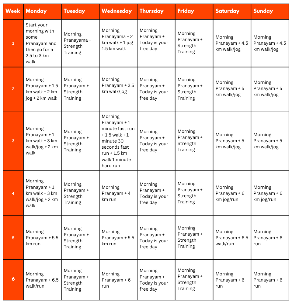
Pro Tip: If you have time, you can skip the Sunday training and go for a long-distance walk or mini day-hike (7–10 km) with a loaded backpack to simulate real trekking conditions. A short 1-day hike around your city/town can help a lot.
Mental Preparation
Physical strength is only half the journey, the other half is mental resilience. The trail takes you through remote clearings, steep climbs, cold starry nights, and no mobile connectivity. Be prepared to:
(I) -
Detach from the digital world.
(II) -
Embrace basic mountain living (camping, toilet tents, limited electricity).
(III) -
Push through moments of fatigue, weather discomfort, or altitude effects.
Himalayan Hikers is a reputable trekking company that places a high priority on safety. Here are some of the safety measures they take to ensure the safety of their clients during the Trek:
Experienced Guides: Himalayan Hikers hires experienced and certified guides who are well-versed in the terrain, weather conditions, and local culture. These guides have first-hand knowledge of the routes and are equipped to handle any emergency situations that may arise.
Proper Gear: The company provides all the necessary gear and equipment to their clients to ensure comfort and safety during the trek.
Hygiene and Sanitation: Himalayan Hikers places great emphasis on hygiene and sanitation during the Trek. They provide clean drinking water, hand sanitizers, and toilet tents to ensure that their clients are healthy and comfortable.
Emergency Services: The company has a well-defined protocol for handling emergency situations. They have a team of trained medical professionals who are available 24/7 and can be quickly mobilized in case of an emergency.
Acclimatization: Himalayan Hikers follows a gradual acclimatization process during treks to ensure that their clients adjust to the high altitude gradually. They also monitor the health of their clients regularly and provide necessary medical attention if required.
Overall, Himalayan Hikers places a great emphasis on safety and takes all necessary measures to ensure the safety and well-being of their clients during treks.
No FAQs available for this trek.


