Announcement: Fixed departure groups for


Dhumdhar kandi Pass trek lies at the height Altitude of 5608 Meters. The trek starts from Sankri base camp which is the base camp of more than twenty five treks and ends at trek Harsil, Gangotri valley, Uttarkashi.
Dhumdhar kandi pass trek is a pass perched between high mountains in India which divides two valley, Yamuna valley and Ganaga Valley in Uttarakhand. It was used as a trade route between Ruinsara Tal and Harsil valley.
Dhumdhar kandi pass Trek is an Enthralling valley in the Garhwal Himalayas of Uttarkashi district in Uttarakhand India, this trek come under Govind Wildlife Sanctuary National park .No doubt, the Himalayas have enchanting beauty, bracing climate and desirable soothing green meadow.
About Dhumdhar Kandi Pass Trek
Bhagirathi River and Yamuna River are fed by the glaciers on either side of the pass. This trek involves descending into Black Peak ice fall which at Dharali Ki Udari meets Bandarpoonch glacier. Go through beautiful mountain villages, surpassing meadows and through big snow fields with overwhelming views of Bandarpoonch, Black Peak and Swargarohini.
Therefore, the trek involves associated challenges but is great for adventure seekers and avid trekkers. In addition to the adventure and beauty, the marvelous panorama views in Uttarakhand Himalayas
Dhumdhar Kandi Pass Complete Guide
Our mission has always been to ensure that no trekker steps into the Himalayas without the right perspective. A trek is not just a checklist of summits; it is a serious commitment to the outdoors. Having the right information is what separates a reckless climb from a soulful journey.
This section serves as your definitive manual for the Dhumdhar Kandi Pass. We have distilled years of mountain experience and real-time feedback into this guide to give you a clear, honest picture of the trail.
We provide this depth of information because we want you to be more than just a visitor—we want you to be a prepared, responsible trekker who respects the mountains as much as we do.
Day 1- Pickup to you from Dehradun railway station – Drive to Sankri Market – 210 Km (8/9 Hours (1920 Meters)
Day 2 – Trek from Sankri to taluka by taxi – 11 km same day trek to Cheludgad camp (12 km) (4/5 Hours) (2600 Meters
Day 3 – Trek from Cheludgad camp to Devsu Bugyal (07 km) (3/4 Hours) (2890 Meters )
Day 4 – Trek from Devsu Bugyal to Ruinsara Tal (12 km) (5/6 Hours) (3500 Meters)
Day 5– Trak from Ruinsara Lake to Kyarkoti Advance Base Camp (7 km) (5/6 hours) (3900 Meter)
Day 6– Trek Kyarkoti Advance Base Camp to Camp 01 Dharon Odari (6 km) (4/5 hours) (4500 Meter)
Day 7– Rest + Acclimatization Day at Camp 01
Day 8– Trek from Dharon Odari (Camp 01) to Camp 02 (04 km) (3/4) (5000 Meter)
Day 9– Trek from Camp 02 to Dhumdhar Kandi Pass (5608 m) and Gantrara gad /Ratiya camp (6 km) (4/5 hours)
Day 10– Trek from Ratiya camp to Kyarkoti camp (9 km) (4/5 hours)
Day 11– Trek from Kyarkoti to Dhorian Gharat (7 km) (4/5 hours)
Day 12– Trek Dharian Gharat to Jhala Harshil (9 km) same day Drive to Dehradun via Uttarkashi (231 km)
Day 1
Day 2
Day 3
Day 4
Day 5
Day 6
Day 7
Day 8
Day 9
Day 10
Day 11
Day 1 : Pickup from Dehradun Railway Station and Drive to Sankri (base camp) by taxi
Total distance – 210 km – 8/9 Hours journey
Mode of journey – By taxi
Altitude – Sankri base camp – 1920 Meters
Night stay – Our Swargarohini Hotel – on twin share basis
Himalayan Hikers organizes transport for trekkers from Dehradun Railway Station in the morning which will leave for Sankri around 6:00 am to 7:00 am.
Dehradun is the capital of Uttarakhand and one of the most beautiful places in India. The main attraction of this place is Rajpur road go through it and get a glimpse of Dehradun’s beauty. Reach Mussoorie after an hour which is also known as “Queen of Hills”. People visit it heavily during vacations with their family and friends.
After half an hour, stop at kempty fall. Have breakfast
there and witness people from different parts of the world. The break will be
of maximum 1 hour. Ahead the peaks are visible and further you will come close
to holy Yamuna River. If you want, then take a short break of 20 minutes and
enjoy being around it.
Then Reach Purola Market around 1:30 pm and take a break there for lunch. After
having lunch proceed to Sankri base camp
Reach check post Naitwar. They will ask for Aadhar cards and some other details. Ahead lies Sankri, enjoy the drive and the wait is soon going to be over. Reach trekkers paradise and the main market of Sankri.
Go to hotel Swargarohini, freshen up and enjoy evening
snacks in the open terrace with great views. You will be provided some details
after which you can go for evening walk but be at the hotel for dinner.
Enjoy delicious dinner and spend comfortable night in the mountains.
Day 2 : Trek from Sankri to Taluka by taxi – 11 km same day trek to Cheludgad camp!
Total distance – 23 km – 4/5 Hours journey
Mode of journey – On foot – 12 km – By taxi 11 km
Altitude – Cheludgad camp – 2600 Meters
Night Stay – Camp in tents – on twin share basis
After breakfast, ready to all trekkers we will drive towards Taluka on the way beautiful forest many species of tree, Taluka is a small village with concrete houses and you can easily find few shops and hotels there. Trek starts from Taluka and the sight of magnificent snow clad mountains accompany you all along the way.
Go ahead, cross a bridge over a stream and follow the trail. Pass through dense forest and a Supin river on the way is visible flowing through the woods below. Continue trekking and a village named Dhatmir comes into right sight.
After some hours of trekking, Supin River can be seen flowing through the woods. Now, again cross the forest section and reach the green fields and a shop on the way.
From here, cross a bridge and a little higher you are welcomed by the surpassing views of towering peaks. To reach Cheludgad camp site today, setup your camps here and retire for the night. Enjoying the first camping night here
Day 3 :Trek from Cheludgad camp to Devsu Bugyal Camp
Trek Distance – 07 km – 3/4 Hours journey
Mode of journey – On foot – 07 km
Altitude – Devsu Bugyal camp – 2890 Meters
Night Stay – Camp site – on twin share basis
After breakfast start the trek the destination for today is Devsu Bugyal camp on a gradual ascent that offers excellent views of the snow-covered mountains and vast valleys with huge waterfalls. Devsu Bugyal 2nd camp of malware lake trek.
The through dense forest and spot rare species of Himalayan birds, animal and exotic flowers. The area is full of birch and spruce.
Ahead, the trail gets steep, cross the last steep ascent and reaches Devsu Bugyal. This is beg meadows, and grassland, There is greenery all over, enlivening nature and open wide meadows which are perfect for camping. From here spot magnificent Black Peak.
Pitch your tents and enjoying beautiful mountain life with us
Day 4 : Trek from Devsu Bugyal to Ruinsara Lake
Trek Distance – 12 km – 5/6 Hours journey
Mode of journey – On foot – 12 km
Altitude – Ruinsara Lake – 3500 Meters
Night Stay – Camp site – on twin share basis
Today start trek to Ruinsara Lake is at an altitude of 3500 meters. In the morning after breakfast and with packed lunch, the trek starts to Ruinsara Lake and ascending again offers mesmerizing views of the snow-Covered mountains and wide valleys with cascading waterfalls. And enjoying one the way Ruinsara lake river
First there was a steep descent of about 100 m to the Ruinsara River & then a steady ascent along beautiful trail that was broken due to landslides at various places – where later during the day the ponies had a lot of difficulty.
Came to an idyllic spot for a nice halt for lunch under trees & over huge boulders. Every long break is bound to have a photo session!
The area is home to a number of Himalayan birds and animals. Trek through the muddy path, cross the slippery areas carefully and further cross Ruinsara River over a bridge.
Ruinsara Tal is a freshwater Lake which lies amidst the pristine peaks and is nestled on the foot of Mt. Kalanag. The region is idyllic and turns lush green after the rains of June and August.
Ruinsara Tal also beautiful lake surrounding mountain range Ruinsara lake camp site is more beautiful camping in the Himalayas.
Tonight you can see full moon light and star – on your tents.
Day 5 : Trak from Ruinsara Lake to Kyarkoti Advance Base Camp
Trek Distance – 07 km – 5/6 Hours journey
Mode of journey – On foot – 07 km
Altitude –Kyarkoti – 3900 Meters
Night Stay – our Camp – on twin share basis
Today you will be trekking towards Kyarkoti Base Camp and from there you can have a glance of Black Peak which will gear you up with enthusiasm. The campsite is Kyarkoti which is a grassland surrounded by mountains and boulders all around.
From here, you can relish magnificent views of Ruinsara Range, Mt. Kalanag, Bandarpoonch and Swargarohini (I) (II) (III). Base camp of kyarkoti
Set your camps here and make good plans for the journey ahead and overcoming challenges. After having food retire for the night.
Day 6 : Trek Kyarkoti Advance Base Camp to Camp 01 Dharon Odari
Trek Distance –06 km – 4/5 Hours journey
Mode of journey – On foot – 06 km
Altitude – Dhorai Odari – 4500 Meters
Night Stay – our Camp – on twin/three share basis
Today start the trek from Kyarkoti Advance Base Camp to Dharon Odari which is your camp 01. The ascent is steep and you are going to gain altitude.
Reach the campsite setup the camps and retire for the night.
Day 7 : Rest + Acclimatization Day at Camp 01
Most trekkers go through Altitude Sickness and because of this health issue the government of Uttarakhand and forest department made a rule i.e. anyone who is going for Dhumdhar kandi pass Trek will spend one days in Camp 01 for proper Acclimatization.
Day 8: Trek from Dharon Odari (Camp 01) to Camp 02.
Distance – 04 km – 3/4 Hours journey
Mode of journey – On foot – 04 km
Altitude – Camp 2 – 5000 Meters
Night Stay – our Camp – on twin/three share basis
After spending two nights at Dharon Odari (Camp 01) leave for Camp 02 which is at an altitude of 5000 meters. After a sheer ascent and a hard trek reach the campsite.
Pitch your tents there and retire for the night.
Day 9 : Trek from Camp 02 to Dhumdhar Kandi Pass (5608 m) and Gantrara gad /Ratiya camp
Trek Distance –06 km – 6/7 Hours journey
Mode of journey – On foot – 06 km
Altitude – Gantrara gad– 5608 Meters
Night Stay – Our campsite – on twin share basis
Start the trek early and analyze the weather conditions. Go towards the pass and climb gradually all the way to reach Dhumdhar Kandi Pass – 5608 meter
You have to cross the humps and the last section is steep so you need ropes to traverse it. Reach the top and the rewards you get are the unmatched views of Bandarpoonch, Black peak and Swargarohini.
Do not spend much time on the top and start descending early because it is steep but further it eases. Reach Gantrara/Ratiya camp, choose the safest place and set your camps, have food and retire for the night.
Day 10: Trek from Ratiya camp to Kyarkoti camp
Distance – 09 km – 4/5 Hours journey
Mode of journey – On foot – 09 km
Altitude – Kyarkoti camp– 5608 Meters
Night Stay – Our Hotel – on twin share basis
After breakfast, Leave Ratiya camp early and head towards the grasslands of Kyarkoti where you stayed on. Setup the camps there and retire for the night.
Day 11: Trek from Kyarkoti to Dhorian Gharat
Before heading towards the itinerary, it is really essential to perceive the reason behind choosing Dhumdhar kandi pass trek.
See firstly, the trekking distance is a total of by taxi 221 +231 Km and on foot 64 km which is to be covered into 8 days. . Dehradun to via Ruinsara Lake, kyarkoti, Black Peak, pass,
Dhumdhar kandi pass trek is a high altitude mountain trek Altitudes is 5608 Meters
The Starting trail is moderate as compare to other treks this is difficult trek. So this trek is not for beginners
Need proper gear & clothing for sub-zero temperature?
You got to see so many heavenly bodies at one place like the panoramic view of the Himalayan ranges, meadows, one of the beautiful Ruinsara lake trek and bali pass on the way beautiful pine forests, different variety of flora and fauna surpassing through bona fide Garhwali heritage and culture.
I think Do spare time in Interaction with our locals’ team, and you will get to know about some of the ancient tales of Indian mythology and our local cultures, this is good ideas for trekkers
And, in summers, the Dhumdhar kandi pass trek turns
totally different and amusing because of meadows, wildflowers and woods
blooming in different colures.
Beautiful landscapes so carry proper photo gear & Extra battery
backup.
The backpack should not exceed 10 to 12 kg only
Altitude we are going to cover in Dhumdhar Kandi Pass
Sankri – 1920 Meters
Cheludgad camp – 2600 Meters
Devsu Bugyal Camp – 3000 Meters
Reinsure Tal – 3500 Meters
Kyarkoti – 3900 Meter
Dhorain Odari – 4500 Meter
Dhumdhar kandi pass – 5608 Meter
So, the best time to do the trek is 2st week of May to last week of November because in pre-monsoon the trail remains covered in snow and the climb gets tough.
We are local team in Uttarakhand so we have more experienced team Himalayan Hikers
No How to Reach the Base Camp available.

Necessary Items for trekkers
Mandatory Documents
Original and photocopy of government photo identity card- (Aadhar Card, Driving License, Voters ID, etc,)
Passport and Visa important to foreigners
Medical Certificate (First part should be filled by the Doctor and Second part by the Trekker)
Declaration Certificates
Note: – Many trekkers commit the same mistake of carrying unnecessary items on a trek which only makes the backpack heavy. It is important to know the right items to carry. It differs from season to season if you are trekking in summers then carry less layers of warm clothing and if you are trekking in winters carry enough layers to protect yourself against chilly cold.
Basic Trekking Gears

The Clothes You Should Bring On Satopanth Expedition

Head Gears

Foot Gears

Personal Care Essentials

Carry a Personal Medical Kit

Are you Looking for Trekking Equipment on Rent?
If any trekker requires trekking equipment on rent, Himalayan Hikers offers the best-quality gear available for rental. Many individuals are in need of such equipment, and renting provides a cost-effective solution, allowing them to access high-quality gear at an affordable price without the need for a significant investment for short-term use.

Trek Equipment You can book directly on first day at the Base Camp.
Note:-
Please take all medicines only when prescribed by the doctor. In case you face any problem during your trek,
discuss and take advice from the Professional guide.
The Trek is one of the most popular treks in Uttarakhand, Himachal,Kashmir,Laddakh,Sikkim,Nepal, requiring both physical preparation and mental readiness. Although it is categorized as a moderate trek, reaches an elevation of over 12,720 feet and traverses remote Himalayan terrain, which can be physically and mentally challenging. Here's how you can prepare yourself for a safe and successful accomplishment of the Trek:
Physical Fitness
Building a good fitness base is essential for every trekker. The Trek itinerary involves 5 to 6 hours of walking every day. Though the trails are well-marked, they are often bumpy and include steep uphill sections, which may affect your stamina. You can overcome your physical limitation with a 6-week training program that you can begin about 2 months before your Trek. Your 6-week fitness routine should include
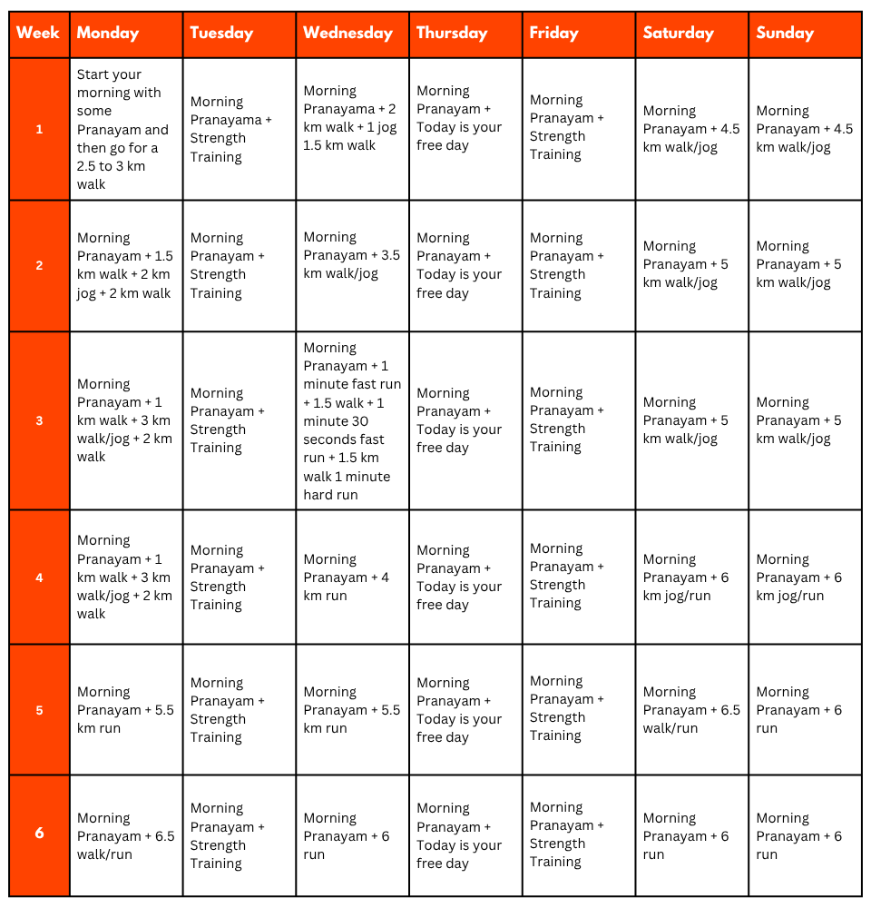
Pro Tip: If you have time, you can skip the Sunday training and go for a long-distance walk or mini day-hike (7–10 km) with a loaded backpack to simulate real trekking conditions. A short 1-day hike around your city/town can help a lot.
Mental Preparation
Physical strength is only half the journey, the other half is mental resilience. The trail takes you through remote clearings, steep climbs, cold starry nights, and no mobile connectivity. Be prepared to:
(I) - Detach from the digital world.
(II) - Embrace basic mountain living (camping, toilet tents, limited electricity).
(III) - Push through moments of fatigue, weather discomfort, or altitude effects.
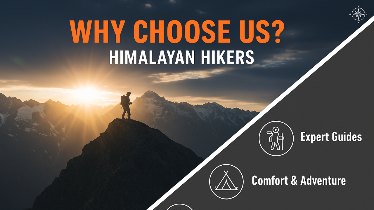
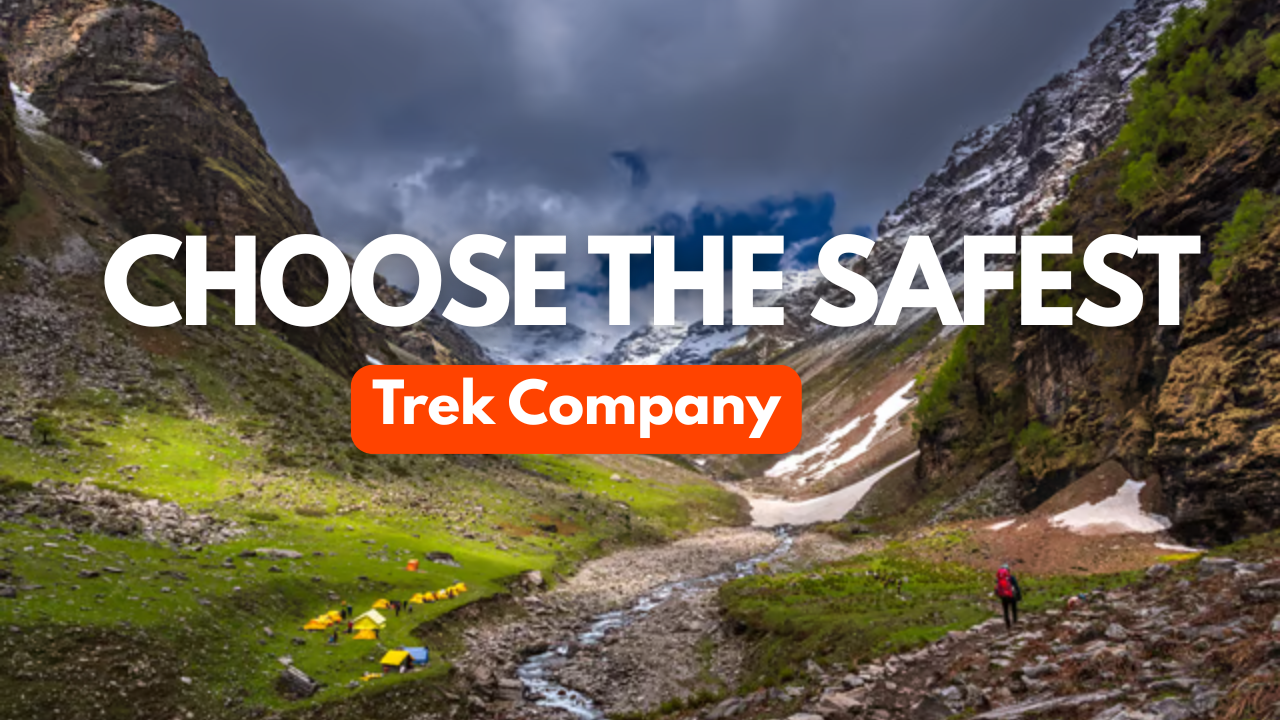
A positive mindset, patience, and the ability to adapt will carry you farther than muscle ever could.Himalayan Hikers is a reputable trekking company that places a high priority on safety. Here are some of the safety measures they take to ensure the safety of their clients during the Trek:
Experienced Guides: Himalayan Hikers hires experienced and certified guides who are well-versed in the terrain, weather conditions, and local culture. These guides have first-hand knowledge of the routes and are equipped to handle any emergency situations that may arise.
Proper Gear: The company provides all the necessary gear and equipment to their clients to ensure comfort and safety during the trek.
Hygiene and Sanitation: Himalayan Hikers places great emphasis on hygiene and sanitation during the Trek. They provide clean drinking water, hand sanitizers, and toilet tents to ensure that their clients are healthy and comfortable.
Emergency Services: The company has a well-defined protocol for handling emergency situations. They have a team of trained medical professionals who are available 24/7 and can be quickly mobilized in case of an emergency.
Acclimatization: Himalayan Hikers follows a gradual acclimatization process during treks to ensure that their clients adjust to the high altitude gradually. They also monitor the health of their clients regularly and provide necessary medical attention if required.
Overall, Himalayan Hikers places a great emphasis on safety and takes all necessary measures to ensure the safety and well-being of their clients during treks.
No inclusions found.
No exclusions found.
Important Note
No important note.
Map not available for this trek.
No FAQs available for this trek.

.webp)