Announcement: Fixed departure groups for


Spanning over 6 days, the Rupin and Supin trek itinerary starts with a scenic 235 km drive from Dehradun to Khanyisani Base camp. From here, the trail meanders through pine forests, alpine meadows, and remote campsites like Sarutal and Badang, steadily gaining altitude. The most exhilarating part of the journey comes on Day 4, when trekkers cross Vijay Top at 12,467 ft, the highest point of the Rupin and Supin trek route, before descending into the Supin valley toward Bhitari village. This crossover experience between the Rupin and Supin valleys makes the trek both rewarding and distinctive.
The total Rupin and Supin trek distance covers around 32 km of trekking with moderate gradients. Most trekkers complete it over five days of walking and one day of return travel, making it an ideal medium-duration Himalayan trek. The Rupin and Supin trek difficulty is rated moderate, suitable for those with prior hiking experience or a good level of fitness.
This trek is open all year round, but the Best Time to Visit The Rupin and Supin trek is from November to March and July to September, when you can experience the snow and explore the lush green trails during the peak flowering season in the monsoon. This region is flanked by the Rupin and Supin rivers that offer a rich experience of both natural beauty and cultural immersion.
Why choose Rupin and Supin Trek?
Before heading towards the itinerary, it is really essential to perceive the reasons behind choosing Rupin and Supin Trek. That’s why we have crafted some important Rupin and Supin Trek Highlight to give you a clear picture of what makes this journey special
Firstly, the trekking distance is a total of 454 km by taxi and 32 km on foot, which is to be covered in 6 Days and 5 Nights. Dehradun via Mussoorie to Khanyisani Base camp, Fhitari, Jakhol, and then Sankri, which is the starting point to more than 30 Treks in Uttarakhand.
- Rupin & Supin Trek is a low altitude mountain trek Altitudes is 3800 Meters.
- The Starting trail is easy to moderate as compare to other treks this is easy trek. So this trek is best for school tour, family and beginners.
- Need proper gear & clothing for sub-zero temperature?
- You got to see so many heavenly bodies at one place like the panoramic view of the Himalayan ranges, you can see pine forests, different variety of flora and fauna surpassing through bona fide Garhwali culture.
- I think Do spare time in Interaction with our local’s team, and you will get to know about some of the ancient tales of Indian mythology and our local cultures, this is good ideas for trekkers.
- Beautiful landscapes so carry proper photo gear & Extra battery backup.
- The backpack should not exceed 10 to 12 kg only.
Walk Along the Rupin and Supin Rivers in the Rupin and Supin Trek
One of the most enchanting parts of the Rupin and Supin Trek is walking beside the pristine waters of the Rupin and Supin rivers. The trail weaves through dense pine forests, open ridgelines, and hidden valleys, with the sound of flowing water keeping you company. As you follow these rivers, you’ll notice familiar landscapes shared by other iconic treks like Kedarkantha and Har Ki Dun. This ever-changing scenery creates a deeply immersive Himalayan experience that stays with you long after the trek ends.
Explore the spellbinding sights and Bitari village and Kasla, fhitari culture in Rupin and Supin Trek
You will see meadows, charming hamlets, snow covered mountains, exotic fields and big rivers so much of variety in a single trek, and this trek gives you a chance to explore the unexplored places. This place has many species of birds and animals you can have a glance of local culture and lives of the people living there, there is a uniquely positioned village “Bitari village” which is at the extreme edge of mountain cliff, which offers you a beautiful scenery. There is a multi-floored Bitari temple where you can have a glimpse of Garhwali culture.
Bhitri village – The first village on Rupin Supin Trek
Our drive is a laborious one and soon we reach the Bhitri village. Altitude 1554 m above mean sea level. A small but beautiful hamlet with wooden homes on stilts, a temple and a very active cricket community. We spent time watching a few boys play and they are no different from their city counterparts when it comes to the knowledge of the game. They know the rules and mimic their idols.
Altitude we are going to cover in Rupin and Supin Trek
- Dehradun – 478 Meter
- Khanyasni camp 1878 Meter
- Sarutal 2000 Meter
- Badang camp 2600 – Meter
- Vijay Top 3800 Meter
- Pachi thach camp 3000 Meter
Rupin and Supin Trek Complete Guide
Our mission has always been to ensure that no trekker steps into the Himalayas without the right perspective. A trek is not just a checklist of summits; it is a serious commitment to the outdoors. Having the right information is what separates a reckless climb from a soulful journey.
This section serves as your definitive manual for the Rupin and Supin Trek. We have distilled years of mountain experience and real-time feedback into this guide to give you a clear, honest picture of the trail.
We provide this depth of information because we want you to be more than just a visitor—we want you to be a prepared, responsible trekker who respects the mountains as much as we do.
Day 1: Drive from Dehradun to Khanyisani Base camp
Drive Distance: 235 km | Drive Duration: 9 to 10 hours | Pick up location: Dehradun railway station | Overnight Stay: Hotel/Camp
Day 2: Trek from Khanyisani Camp to Sarutal camp
Altitude Gain: 6,154 ft to 6,561 ft | Trek Distance: 5 km | Trek Duration: 3 to 4 hours | Overnight Stay: Shared Tents
Day 3: Trek from Sarutal camp to Badang camp
Altitude Gain: 6,561 ft to 8,530 ft | Trek Distance: 8 km | Trek Duration: 5 to 6 hours | Overnight Stay: Shared Tents
Day 4: Trek from Badang camp to Pachi Thach campsite via Vijay Top
Altitude Gain & Loss: 8,530 ft to 12,467 ft to 9,842 ft | Trek Distance: 12 km | Trek Duration: 6 to 7 hours | Overnight Stay: Shared Tents
Day 5: Trek from Pachi Thach campsite to Fhitari village
Trek Distance: 7 km | Trek Duration: 4 to 5 hours | Drive Distance: 36 km by taxi | Overnight Stay: Hotel in Sankri village
Day 6: Drive from Sankri to Dehradun by taxi
Drive Distance: 210 km | Drive Duration: 9 to 10 hours
Day 1
Day 2
Day 3
Day 4
Day 5
Day 6
Day 1 : Pickup to you from Dehradun railway station drive to Khanyisani camp
Total distance 235 km – 9/10 Hours journey
Mode of journey – By taxi
Altitude – Khanyisani camp – 1878 Meter
Night stay – Our Campsite – on twin share basis
Himalayan Hikers organizes transport for trekkers from Dehradun Railway Station in the morning which will leave for Khanyisani camp around 6:00 am to 7:00 am.
Dehradun is the capital of Uttarakhand and one of the most beautiful places in India. The main attraction of this place is Rajpur road go through it and get a glimpse of Dehradun’s beauty. Reach Mussoorie after an hour which is also known as “Queen of Hills”. People visit it heavily during vacations with their family and friends.
After half an hour, stop at kempty fall. Have breakfast there and witness people from different parts of the world. The break will be of maximum 1 hour. Ahead the peaks are visible and further you will come close to holy Yamuna River. If you want, then take a short break of 20 minutes and enjoy being around it.
Further you will cross the small markets of Nainbagh, Damta and Naugaon. Reach Purola around 1:30 pm and take a break there for lunch. After having lunch proceed to Sankri via Jarmola. From there the back of Kedarkantha is visible. Go through the picturesque zig zag road amid pine forest of Jarmola.
Reach Mori and after 1 hour you will come across a check post Naitwar, reaching the Khanyisani camp site you will enjoy the tea or snacks.
Day 2 : Khanyisani camp to Sarutal camp
Total distance 08 km – 4/5 Hours journey
Mode of journey – On foot
Altitude Sarutal camp – 2000 Meter
Night Stay – Our Campsite – on twin share basis
Post breakfast start your trek by following the right of
river Rupin (1500 m) to Pujali and Bitri village. There are many apple orchards
and fields at Bitri which lies at an altitude of 2000 m.
You can see traditional values and local life of the villagers. Wheat and
cultivation of red rice is done here. Now, the trail takes you through dense
pine forest from where Himachal Mountains will be visible and also Changsheel
valley can be seen from the top of Bitri village.
We will setup our camps a kilometer further at a wide meadow “Sarutal”. After
setting up the camps and having food retire for the night.
Day 3 :Trek from Sarutal camp to Badang camp
Trek Distance 08 km – 5/6 Hours journey
Mode of journey – On foot
Altitude – Badang camp – 2600 Meter
Night Stay – Our Camp site – on twin share basis
Have breakfast at the camp and then start you trek towards
Badang camp . A high ridge divides the valley of Rupin and Supin valley which
gives panorama views of the mountains.
Towards the north you can see peaks of Himachal with amusing views of a unique
mountain with 4 peaks Swargarohini. Go through dense forest sections and
gradually gain height. Rupin and Supin River are visible on the meandering
course, you will come across streams on the way where you can take breaks.
Badang is a green wide meadow and a great camping spot. Setup your camps and
retire for the night.
Day 4 : Trek from Badang camp to via vijay Top (3800 Meter )Pachi thach camp
Trek Distance 12 km – 5/6 Hours journey
Mode of journey – On foot
Altitude – Vijay top – 3800 Meter
Night Stay – Camp site – on twin share basis
After breakfast start your trek to Pachi thach via Vijay Top which is at a height of 3800 meter The climb to the top is steep with some spell binding views of snow covered mountains and magnificent views of Vishkhopri, Obra valley and Khimloga Pass. Enjoy the panorama views there and then start the descent to Pachi Thach.
After a restful night, Day 3 begins with determination. This is the big day. We are expected to do 12 kms. The climb to Vijay Top, atclose to 3800 meter is the highlight. The landscape is pretty much the same with streams, trees and meadows. Flowers of every color imaginable dot the landscape. We get to see some towering peaks in the distance. Clouds and mist roll in and out and the sun remains hidden behind the dark clouds. We reach Vijay Top and the stunning vista makes it all worth it. A total of 3.5 hours has been spent
Descending trek is through thick forest and there is dense vegetation. Reach the campsite and explore it. After setting up the camps retire for the night.
Day 5 : Trek from Pachi thach camp to Fhitari village (7 km) (4/5 Hours) same day drive to Sankri (36 km)
Trek Distance 07 km – 4/5 Hours journey
Mode of journey – On foot
Altitude – Sankri – 1920 Meter
Night Stay – Our Hotel – on twin share basis
Today after breakfast trek start, It was our last 7 km trek
down to the base camp at Sankri village. Leave the campsite of pachi Thach,
follow the trail and you will see many farms on the way, ahead is a village
named Fhitari and Dhara. There is a big temple of Lord Someshwar at right of
Supin River which is worshiped by the villagers.
Jakhol is the entrance to Supin valley, it is a biggest village. Spend some
time there with villagers has a glimpse of their local lifestyle and how they
work to earn their living, after that leave for Sankri by a taxi.
Overnight stay and dinner in our hotel “Swargarohini”
Day 6 : Drive from Sankri to Dehradun by taxi
Total distance 210 km – 8/9 Hours journey
Mode of journey – by taxi
Today – It is your last breakfast on this trek with Himalayan Hikers team. The certificates will be given and after some beautiful photos we will bid you all a goodbye from Sankri.
What is the Difficulty level of Rupin and Supin Trek?
The Rupin and Supin Trek Difficulty is rated as moderate trek, with a gradual increase in challenge each day. It’s suitable for trekkers with decent fitness and some prior experience in the Himalayas. Here’s a day-by-day Rupin and Supin trek difficulty breakdown to help you understand what to expect:
Day 2: KhanyisaniCamp to Sarutal Camp
- Altitude Gain: 6,154 ft to 6,561 ft
- Trek Distance: 5 km
- Difficulty: Easy to Moderate
This is a gentle start to the trek. The trail ascends gradually through forested areas with occasional clearings. Terrain is mostly well-marked and not too steep. It’s a good day for acclimatization and easing into the rhythm of trekking.
Day 3: Sarutal Camp to Badang Camp
- Altitude Gain: 6,561 ft to 8,530 ft
- Trek Distance: 8 km
- Difficulty: Moderate
The elevation gain is significant today, and you’ll start to feel the thinner air. The trail climbs steadily through mixed terrain—alpine meadows, rocky patches, and forest sections. Expect a longer walking duration and slightly more physical exertion.
Day 4: Badang Camp to Pachi Thach via Vijay Top
- Altitude Gain/Loss: 8,530 ft to 12,467 ft to 9,842 ft
- Trek Distance: 12 km
- Difficulty: Moderate to Difficult
This is the toughest day of the trek. A steep ascent to Vijay Top, followed by a sharp descent to Pachi Thach. The climb is demanding, especially near the top, where the trail gets steeper and thinner. Weather can change quickly, so extra caution is needed.
Day 5: Pachi Thach to Fhitari Village then Sankri
- Trek Distance: 7 km
- Difficulty: Easy to Moderate
The trail descends through forest and pastureland. It’s easier on the lungs but can be hard on the knees. Trekking poles help here. The final descent offers beautiful views and a gentle end to a challenging trek. After a 4-5 hours descent you will reach Sankri village where you will spend the night in a beautiful hotel. On Day 6 of your Rupin and Supin trek, we will leave this place for Dehradun via shared taxi.
Pro Tip: Day 1 and Day 7 don’t count because you won’t be trekking on those days.
What is the best time to visit Rupin and Supin trek?
The Rupin and Supin trek is open to all seasons. But the best time to visit Rupin and Supin trek is from best time to visit the Rupin and Supin trek is from November to March and July to September. You can experience gorgeous blooming flowers in monsoon and snow-capped views of prominent mountain peaks like Kedarkantha, Bandarpoonch, black peak, and more.
Winter – November to March
Winter is the best time to do Rupin and Supin trek, it’s the time when everything turns into a world of snow and silence. From mid-November, the snow begins to cover the entire Rupin and Supin region with soft white layers of powdery snow. Which transforms into a white magical world by the peak winter months (December, January, and February), making it the best winter trek in Uttarakhand.
Unlike the Kedarkantha trek or Dayara Bugyal Trek, the Rupin and Supin trek is a peaceful trek offering a spectacular visual feast of frozen glacial lake Sarutal and prominent mountain massifs of Kedarkantha and Bandarpoonch from Vijay Top. The winter in this trek is cold, but the views are worth your every effort. This is the season for trekkers who enjoy the quiet beauty of winter and don’t mind a little challenge.
Snow Conditions: This period offers stunning snow-covered landscapes, making it a fantastic time for snow trekking and winter photography.
Temperature: You can expect biting cold temperatures, ranging from -5°C to -10°C at night and around 5°C to 10°C during the day.
Summer – April to June
Summer is a gentle season in these valleys. From April to June, the snow melts, and the mountains breathe life again. The trails are lined with blooming wildflowers, and the meadows near Sarutal and Badang campsites turn a bright green. Water flows freely in the small brooks, and the weather stays enjoyable. Views from Vijay Top stretch for miles, and you can see snow still lingering on the far-off peaks. It’s a peaceful scenery for an ideal summer trek in Uttarakhand.
Rupin and Supin Trek Weather & Temperatures: When plains are burning with scorching summer heat, the Rupin and Supin treks offer pleasant weather conditions with a dreamlike scenery. The temperature ranges from 10°C to 20°C during the day and 1°C to 5°C during the night, which gives a winter chill to Delhi, UP, and other tropical states of India.
Monsoon – July to September
Monsoon brings a dramatic beauty to the Rupin and Supin trek. Between July and September, the forests glow deep green, and the meadows bloom with tiny alpine flowers. Mist curls around the hills, and sometimes the mountains appear only for a moment. But when they do, the miraculous views are enough to steal your breath. Rivers like the Rupin roar with rainwater, and the trails feel alive. It’s a time for those who love the wild side of nature.
Weather & Temperatures: It is 10°C to 15°C during the day and 1°C to 8°C during the night. However, the weather during this season can be highly unpredictable. So, make sure to carry a poncho and rain cover for your backpacks.
Autumn – October to early November
Autumn is crisp, colorful, and clear. From October to early November, the leaves turn gold and orange, painting the valleys in warm light. The skies stay cloudless for days, offering perfect views of Black Peak, Swargarohini, and other giants. The trails are dry and firm, making it easy to walk. Campsites feel peaceful, and the nights are just cold enough for cozy layers and stargazing. It’s the perfect balance, neither too hot nor too cold, and ideal for photography and quiet reflection.
Temperatures: You can expect temperatures to range from 5°C to 15°C during the day and be cooler at night.
The Rupin and Supin Trek begins from Khanyisani Base camp, a remote yet accessible spot nestled in the Garhwal Himalayas. Reaching Khanyisani Is relatively easy, especially if you’re starting from Dehradun, a major transit hub in Uttarakhand. Here’s how you can get there:
1. By Air
- Nearest Airport: Jolly Grant Airport, Dehradun (235 km from Khanyisani)
- Details: Regular flights connect Dehradun with major Indian cities like Delhi, Mumbai, and Bangalore. From the airport, you’ll need to hire a taxi or take a shared vehicle to Khanyisani.
2. By Train
- Nearest Railway Station: Dehradun Railway Station
- Details: Trains to Dehradun are available from cities such as Delhi, Kolkata, and Chandigarh. After reaching Dehradun, you’ll travel to Khanyisani By road—either via a private vehicle or shared transport.
3. By Road
Rupin and Supin Trek Distance from Dehradun
- Distance: Approximately 235 km
- Travel Time: Around 9 to 10 hours
Transport Options:
- Private Taxi: Comfortable and direct, ideal for those who prefer flexibility.
- Shared Jeep/Taxi: Budget-friendly option, commonly used by trekkers.
- Self-Drive: A scenic route with winding mountain roads, passing through pine forests and charming villages.
4. Dehradun to KhanyisaniRoute Overview
- Dehradun to Mussoorie: Begin on NH 7 towards the hill station of Mussoorie.
- Mussoorie to Purola: Drive through winding roads with beautiful valley views.
- Purola to Mori: The route narrows and becomes more remote, surrounded by dense forest.
- Mori to Khanyisani: A short, signposted drive through quiet mountain terrain leads to the base camp.

Necessary Items for trekkers
Mandatory Documents
Original and photocopy of government photo identity card- (Aadhar Card, Driving License, Voters ID, etc,)
Passport and Visa important to foreigners
Medical Certificate (First part should be filled by the Doctor and Second part by the Trekker)
Declaration Certificates
Note: – Many trekkers commit the same mistake of carrying unnecessary items on a trek which only makes the backpack heavy. It is important to know the right items to carry. It differs from season to season if you are trekking in summers then carry less layers of warm clothing and if you are trekking in winters carry enough layers to protect yourself against chilly cold.
Basic Trekking Gears

The Clothes You Should Bring On Satopanth Expedition

Head Gears

Foot Gears

Personal Care Essentials

Carry a Personal Medical Kit

Are you Looking for Trekking Equipment on Rent?
If any trekker requires trekking equipment on rent, Himalayan Hikers offers the best-quality gear available for rental. Many individuals are in need of such equipment, and renting provides a cost-effective solution, allowing them to access high-quality gear at an affordable price without the need for a significant investment for short-term use.

Trek Equipment You can book directly on first day at the Base Camp.
Note:-
Please take all medicines only when prescribed by the doctor. In case you face any problem during your trek,
discuss and take advice from the Professional guide.
The Trek is one of the most popular treks in Uttarakhand, Himachal,Kashmir,Laddakh,Sikkim,Nepal, requiring both physical preparation and mental readiness. Although it is categorized as a moderate trek, reaches an elevation of over 12,720 feet and traverses remote Himalayan terrain, which can be physically and mentally challenging. Here's how you can prepare yourself for a safe and successful accomplishment of the Trek:
Physical Fitness
Building a good fitness base is essential for every trekker. The Trek itinerary involves 5 to 6 hours of walking every day. Though the trails are well-marked, they are often bumpy and include steep uphill sections, which may affect your stamina. You can overcome your physical limitation with a 6-week training program that you can begin about 2 months before your Trek. Your 6-week fitness routine should include
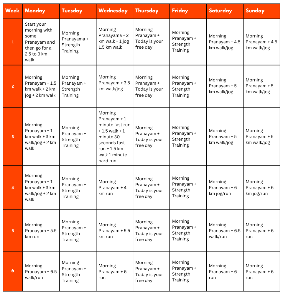
Pro Tip: If you have time, you can skip the Sunday training and go for a long-distance walk or mini day-hike (7–10 km) with a loaded backpack to simulate real trekking conditions. A short 1-day hike around your city/town can help a lot.
Mental Preparation
Physical strength is only half the journey, the other half is mental resilience. The trail takes you through remote clearings, steep climbs, cold starry nights, and no mobile connectivity. Be prepared to:
(I) - Detach from the digital world.
(II) - Embrace basic mountain living (camping, toilet tents, limited electricity).
(III) - Push through moments of fatigue, weather discomfort, or altitude effects.
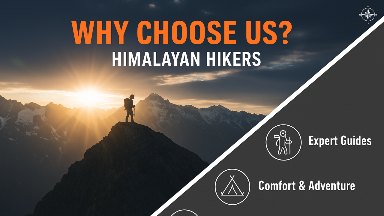
A positive mindset, patience, and the ability to adapt will carry you farther than muscle ever could.Himalayan Hikers is a reputable trekking company that places a high priority on safety. Here are some of the safety measures they take to ensure the safety of their clients during the Trek:
Experienced Guides: Himalayan Hikers hires experienced and certified guides who are well-versed in the terrain, weather conditions, and local culture. These guides have first-hand knowledge of the routes and are equipped to handle any emergency situations that may arise.
Proper Gear: The company provides all the necessary gear and equipment to their clients to ensure comfort and safety during the trek.
Hygiene and Sanitation: Himalayan Hikers places great emphasis on hygiene and sanitation during the Trek. They provide clean drinking water, hand sanitizers, and toilet tents to ensure that their clients are healthy and comfortable.
Emergency Services: The company has a well-defined protocol for handling emergency situations. They have a team of trained medical professionals who are available 24/7 and can be quickly mobilized in case of an emergency.
Acclimatization: Himalayan Hikers follows a gradual acclimatization process during treks to ensure that their clients adjust to the high altitude gradually. They also monitor the health of their clients regularly and provide necessary medical attention if required.
Overall, Himalayan Hikers places a great emphasis on safety and takes all necessary measures to ensure the safety and well-being of their clients during treks.
No inclusions found.
No exclusions found.
Important Note
No important note.

No FAQs available for this trek.

.webp)