


Price:₹21,000.00
The Kedartal trek is a popular trekking route in the Indian state of Uttarakhand, known for its stunning natural beauty and challenging terrain.
Kedartal Trek is in the Garhwal Himalayas at an altitude of 4912 m. Perhaps, it is the source of Kedar Ganga and it is believed that it is a contribution to Bhagirathi by Lord Shiva. Kedartal Trek is an Enthralling Gangotri valley in the Garhwal Himalayas of Uttarkashi district in Uttarakhand India, this trek come under Gangotri National park.
No doubt, the Himalayas have enchanting beauty, bracing climate, and desirable soothing green meadow. So, what else can be better than spending some days here in the serenity!
The Kedartal Trek, Here are some of the most important highlights of this trek:
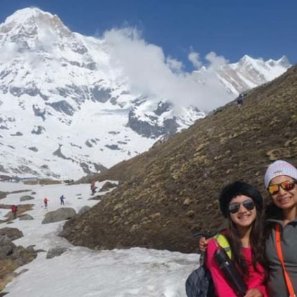
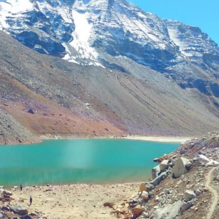
- Kedartal Lake: The trek leads to Kedartal, a glacial lake situated at an altitude of 4,750 meters. The lake is surrounded by towering peaks, including Thalay Sagar and Bhrigupanth, and is known for its crystal-clear waters and stunning reflection of the surrounding mountains.
- Gaumukh Glacier: The trek passes through the Gaumukh Glacier, the source of the holy Ganges River. The glacier is a sight to behold, with its pristine ice formations and stunning views of the surrounding mountains.
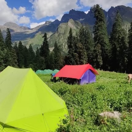
- High Altitude Camping: The trek includes camping at high altitudes, providing an opportunity to experience the beauty and serenity of the Himalayas. The camping sites offer stunning views of the surrounding mountains, and the clear night skies are perfect for stargazing.
- Gangotri Temple: The trek starts from the holy town of Gangotri, which is home to the famous Gangotri Temple. The temple is dedicated to the goddess Ganga and is an important pilgrimage site for Hindus.
- Local Culture: The trek passes through several small villages, providing an opportunity to experience the local culture and interact with the friendly villagers. The villages are known for their traditional architecture and handicrafts, and the local cuisine is a highlight of the trek.
Overall, the Kedartal Trek is a wonderful opportunity to experience the natural beauty and cultural richness of Uttarakhand, and it is highly recommended for experienced trekkers who are up for a challenging adventure.
Should you trek to Kedartal or not, and do so because of it?
These treasures are worth thinking about, how beautiful and huge these treks are, when you go here you will find yourself, Kedartal trek which starts from Uttarkashi Gangotri Dham in Uttarakhand State,
The Kedaratal trek is a wonderful and natural tal, which is 17 kilometers from Gangotri, these Tal are in the middle of beautiful hills with an altitude of about 4,912 meters. For Kedartal, we need to travel only after getting a permit from the forest, these treks from Gangotri are about to climb, when we leave from Gangotri for the Bhojkharak camp, then the stepping starts from the one who feels very tired. Yes, but for those who are adventure lovers, they are nothing but adventure, at a distance of about 8 km from Gangotri, the route passes through the magnificent and difficult paths,
Even from Bhoj Kharak camp to Kedarkharak, today is a very good day, but today you will have to climb about 5 Km from near Grass and Kedarganga. If you are in luck, these camps are very beautiful from here and the mountain range starts to appear, from Kedarkharak to Kedartal are just 4 kilometers away which are very spectacular, you will feel happy after going here and here from here you will be able to see other mountain ranges close to Thalay Sagar 6,904 meters, Peak, Meru Peak 6,660 meters.etc
The climate and temperature here vary from time to time, so you should come with your preparation according to the time and the months, it can also be difficult to trek to without out local ,

Get the closest view of Mountains of Kedartal
This place is amidst the tall standing mountains all covered by snow, you will get the magnificent views of snow-covered mountains, you don’t often get the close view of mountains on many treks, but at Kedar Tal, you will get close and majestic views of them. Mountains like Thalay Sagar, Bhrigunath, Meru, and Mt. Gangotri and Manda Parvat are closely visible.
The trail goes through pine forest and the climb is steep, it is moderate to difficult trek as the climb is steep and there are landslide-prone areas and you have to go through them, it is an adventurous trek and not recommended for beginners but adventure lovers can choose this unique glacial lake trek.
Best Time to Do Kedartal Trek ?
Kedartal trek is a very beautiful and an uphill trek in the Uttarakhand Himalayas Gangotri , The Kedaratl Trek is great for those people who have a great passion for mountaineering and consider it a special purpose in their life. Kedaratl is such a trek where you get to see more than one Himalayan mountain range. surrounding, Kedartal,
We are the local people in uttarakhand District of Uttarkashi who are doing this trek for years, we have every experience related to this trek. every year come with us around 15 above Customized group this trek
The right time to do Kedartal trek is from April 2nd week to the last of June and then from the last of August to the last month of October.
specially in the months of April, may, and June, snow is found in abundance here, which makes your trek very memorable and also a little difficult after Gangotri to Bhojkharak because this is uphill trek route . So this trek should not be considered too easy
Kedartal trek in April to June ?
Kedartal Trek Month in April and june gives a slightly different experience to Trekkers because in May you start getting snow Kedarkharak Camp
The Kedartal trek starts from Gangotri in Uttarakhand which comes in Gangotri National Park Range
In April, May and June, you get a combination of both greenery and snow, which makes the trek very spectacular. The weather in April, May and June is quite good and trek friendly, which makes trekking a lot of fun.
During the day the temperature of Kedartal trek is around ( 4°C to 15 °C and during the night the temperature comes down to -3 °C to -5 °C which is nights cold during the trek
You will never consider yourself boring in during the Kedartal Trek, this trek can give you nothing but joy, You will get to see the Garhwal culture and Gangotri dhma yatra in this trek which will always keep you connected towards the mountain. Himalayas
Kedartal trek in September or October
Kedartal trek is a different in the months of September and October, this is because you will find snow only Kedartal Glacier
But the beauty of the trek will not be lacking, the trek and nature adorn themselves with time and in different colors. Month of September and October are very good days to trek, at this time total greenery and at the end of October sometimes you can get to see live snow fall.
During the day the temperature of Kedartal trek is around Day time 5°C to 10 °C and during the night the temperature comes down to 6 °C to – 3 °C which is very confirmable,
At this time the weather here will be very good for you , At this time it is even safe to trek here and there is no rain.
About Base camp Kedartal at Gangotri
Gangotri is a starting point of Kedartal trek, Gangotri is a holy town perched at an altitude of 3,092 m on Bhagirathi River’s banks in Uttarkashi district. According to the legend, it is Goddess Ganga’s shrine and this pious site is the part of Chota Char Dham which holds a great place in the heart of Hindu mythology and Hindu devotees.
History and Significance:
- Historical Significance: Gangotri Dham holds immense religious significance in Hinduism. It is believed to be the place where Goddess Ganga descended to Earth from heaven, following the prayers of King Bhagirath to cleanse the souls of his ancestors.
- Mythological Legends: According to Hindu mythology, Goddess Ganga initially descended to Earth with such force that it would have flooded the entire Earth. Lord Shiva intervened by catching her in his locks, thereby reducing the impact of her descent. This event is depicted in the form of a stone slab near the Gangotri Temple.
- Shrine Establishment: The Gangotri Temple, dedicated to Goddess Ganga, is believed to have been built by the Gorkha General Amar Singh Thapa in the 18th century. It is situated on the banks of the Bhagirathi River and serves as a major pilgrimage site for Hindus.
Altitude and Location:
- Altitude: Gangotri is situated at an altitude of approximately 3,100 meters (10,200 feet) above sea level, making it a high-altitude pilgrimage site in the Garhwal Himalayas.
- Location: Gangotri is located in the Uttarkashi district of Uttarakhand, India. It is nestled amidst the snow-capped peaks and pristine valleys of the Himalayas, offering breathtaking views of the surrounding landscape.
Route and Accessibility:
- Route: Gangotri is accessible via road from various major cities and towns in Uttarakhand. The nearest major town is Uttarkashi, which is approximately 99 kilometers away. From Uttarkashi, one can travel to Gangotri by road, which involves a scenic journey through mountainous terrain.
- Accessibility: Gangotri is well-connected by road during the summer months when the roads are open. However, during the winter season, the region experiences heavy snowfall, leading to road closures and limited accessibility.
Popularity and Pilgrimage:
- Pilgrimage Destination: Gangotri Dham is one of the Char Dham pilgrimage sites in Hinduism, along with Yamunotri, Kedarnath, and Badrinath. Thousands of pilgrims undertake the arduous journey to Gangotri every year to pay homage to Goddess Ganga and take a holy dip in the sacred waters of the Bhagirathi River.
- Tourism: Apart from its religious significance, Gangotri also attracts tourists and adventure enthusiasts due to its stunning natural beauty, serene ambiance, and opportunities for trekking and mountaineering in the surrounding Himalayan region.

Why choose Kedartal Trek?
Before heading towards the itinerary, it is really essential to perceive the reason behind choosing Kedartal trek.
See firstly, the trekking distance is a total of by taxi 516 Km both sides and on foot 36 km which is to be covered into 7 days. Dehradun to Dehradun
Kedartal trek is a high altitude mountain trek Altitudes is 4912 Meters
The Starting trail is moderate as compared to other treks this is a difficult trek. So this trek is not for beginners
Need proper gear & clothing for sub-zero temperature?
You got to see so many heavenly bodies at one place like the panoramic view of the Himalayan ranges, you can see pine forests, different variety of flora and fauna surpassing through bona fide Garhwali culture.
I think Do spare time in Interaction with our local team, and you will get to know about some of the ancient tales of Indian mythology and our local cultures, this is good ideas for trekkers
Beautiful landscapes so carry proper photo gear & Extra battery backup.
The backpack should not exceed 10 to 12 kg only
How Difficult is Kedartal Trek
The Kedartal Trek is considered to be of moderate to difficult level. Here’s a breakdown of the factors contributing to its difficulty:
- Terrain: The trek involves traversing through varied terrain, including steep ascents, rocky paths, moraines, and sometimes snow-covered sections, especially at higher altitudes. The trail can be challenging, requiring good physical fitness and endurance.
- Altitude: Kedartal is situated at an altitude of approximately 4,912 meters (16,119 feet) above sea level. Trekking to such high altitudes poses challenges related to altitude sickness, including shortness of breath, headaches, and fatigue. Proper acclimatization and gradual ascent are essential to minimize the risk of altitude-related issues.
- Weather: Weather conditions in the Himalayan region can be unpredictable and harsh, particularly during the monsoon and winter seasons. Trekkers may encounter rain, snowfall, high winds, and temperature fluctuations, adding to the difficulty of the trek. It’s crucial to be prepared for varying weather conditions and to plan the trek during favorable seasons.
- Duration: The Kedartal Trek typically takes around 6-7 days to complete from Dehradun to Dehradun, depending on the chosen itinerary. Long trekking days, coupled with challenging terrain and altitude, require stamina and determination to sustain the journey.
- Remote Location: Kedartal is located in a remote and isolated area of the Gangotri National Park. Facilities such as accommodation, food, and medical assistance are limited along the trail, making it essential for trekkers to be self-sufficient and well-prepared with necessary supplies.
- Technical Sections: While the trek does not involve technical climbing, there are certain sections that may require careful negotiation, particularly around the moraines and rocky patches. Basic trekking skills and proper footwear are necessary for navigating these sections safely.
Overall, while the Kedartal Trek offers breathtaking views of the Himalayan landscape and a rewarding experience for trekkers, it requires adequate preparation, physical fitness, and mental resilience to overcome its challenges. Trekkers are advised to undertake proper training, acclimatization, and thorough planning before embarking on this adventure.
Kedartal trek safe for me ?
The Kedartal trek is not typically recommended for beginners due to its challenging terrain, high altitude, and remote location. However, with proper preparation, guidance, and assistance from experienced trekkers or tour operators, beginners can undertake this trek safely. Here’s some detailed information about the trek, including the route and essential considerations:
Route Overview:
- Starting Point: The trek usually starts from Gangotri, a town in Uttarakhand, India, situated at an altitude of approximately 3,100 meters (10,200 feet) above sea level.
- Acclimatization: Spending a couple of days in Gangotri for altitude acclimatization is crucial before starting the trek. This helps reduce the risk of altitude sickness as you ascend to higher altitudes.
- Trekking Route:
- Gangotri to Bhoj Kharak: The initial part of the trek involves a gradual ascent through forests and meadows, passing by the settlement reaching Bhoj Kharak.
- Bhoj Kharak to Kedar Kharak: The trail continues with a moderate ascent, offering views of snow-capped peaks and glaciers, leading to the campsite of Kedar Kharak.
- Kedar Kharak to Kedartal: The final leg of the trek involves a steep climb over rocky terrain and moraines, culminating in the breathtaking Kedartal Lake at an altitude of about 4,912 meters (16,119 feet) above sea level.
- Return Route: After spending time at Kedartal and soaking in the panoramic views, trekkers return via the same route back to Gangotri.
Essential Considerations:
- Fitness Level: While the trek is challenging, trekkers with a good level of fitness and stamina can undertake it. It’s advisable to engage in physical training and endurance exercises before the trek to prepare for the rigors of the journey.
- Altitude Acclimatization: Adequate acclimatization is essential to prevent altitude sickness. Trekkers should ascend gradually, stay hydrated, and be mindful of any symptoms of altitude-related illnesses.
- Weather Conditions: The weather in the Himalayas can be unpredictable. Trekkers should be prepared for varying weather conditions, including rain, snowfall, and temperature fluctuations, by carrying appropriate clothing and gear.
- Guidance and Assistance: Beginners are advised to trek with experienced guides or join organized trekking groups to ensure safety and navigation along the route. Guides can provide valuable insights, assistance, and support throughout the trek.
- Permits and Permissions: Obtain necessary permits from the forest department or authorized agencies for trekking in the Gangotri National Park.

Why you should choose us for kedartal
We’re here to give you the greatest experience possible through the eyes of highly skilled and qualified specialists who have a passion for adventure sports. We are community members attempting to promote our favorite adventure sports while also supporting local businesses. We, at Himalayan hikers, dedicate ourselves to providing you with an unforgettable experience.
Himalayan Hikers always make the trek from Trekkers memorable, I insist that you do not face any problem in any trek and you can always have a pleasant experience.
Weather conditions
The weather conditions during the Kedartal trek can vary significantly depending on the time of year. Here’s a general overview of the weather conditions you might encounter during different seasons:
Summer (May to June):
- Temperature: During the summer months, temperatures in the Gangotri region and along the trekking route are relatively mild during the day, ranging from 10°C to 20°C (50°F to 68°F). However, temperatures can drop significantly at night, especially at higher altitudes, with temperatures occasionally dipping below freezing.
- Precipitation: Summer is generally considered the best time to undertake the Kedartal trek as precipitation is relatively low. Rainfall is minimal, and there is less chance of encountering snowfall along the trail.
- Daylight Hours: Days are longer during the summer months, providing more daylight hours for trekking activities.
Monsoon (July to September):
- Temperature: Monsoon brings warmer temperatures during the day, ranging from 15°C to 25°C (59°F to 77°F). However, humidity levels are higher, making the trek feel more strenuous.
- Precipitation: Monsoon brings heavy rainfall to the region, especially in July and August. Trekking during this time can be challenging due to muddy trails, slippery terrain, and the risk of landslides. It’s advisable to check weather forecasts and exercise caution.
- Visibility: Cloud cover and mist may reduce visibility, obscuring panoramic views of the surrounding mountains and landscapes.
Autumn (October to November):
- Temperature: During autumn, temperatures start to drop as winter approaches. Daytime temperatures range from 5°C to 15°C (41°F to 59°F), while nights become colder with temperatures below freezing at higher altitudes.
- Precipitation: Precipitation decreases compared to the monsoon season, making it a favorable time for trekking. However, occasional rainfall or snowfall can still occur, especially in late November.
- Clear Skies: Autumn offers clear skies and better visibility, allowing trekkers to enjoy panoramic views of the Himalayan peaks and landscapes.
Altitude we are going to cover in Kedartal
Gangotri – 3415 Meter
Bhoj Kharak – 3870 Meter
Kedar Kharak – 4270 Meter
Kedartal – 4912 Meter

Key Points of Kedartal Trek
Duration: – 6 Nights 7 Days – from Dehradun to Dehradun
Base camp: – Gangotri
Summer Temperature: – Day 5°C to 10°C) Night -2° C to 5° C)
Kedartal Altitude: – 4912 m
Best Time: – May, June, September, October
Trek Level: – Moderate-Difficult
Trek distance: – On foot 36 Km – By taxi 516 km
Kedartal Trek Route – Start from Dehradun, Muussoorie, Suwakholi, Uttarkashi, Gangotri, Bhojkharak, Kedarkharak, Kedartal
Short Itinerary of Kedartal Trek
Day 1- Pickup to you from Dehradun railway station – Drive to Gangotri – 258 km) (10/11 Hours) (3415 Meter overnight stay Hotel
Day 2 – Trek from Gangotri to Bhoj Kharak camp (08 km) (5/6 Hours) (3780 Meter) overnight stay Camp
Day 3 – Trek from Bhoj Kharak to Kedar Kharak (5 km) (4/5 Hours) (4270 Meter) overnight stay Camp
Day 4 – Exploration Day Kedartal (4912 Meter) and Thalay Sagar back to camp (6/7 Hours) overnight stay Camp
Day 5 – Trek from Kedar Kharak to Bhoj Kharak camp (05 km) (3/4 Hours) (3780 Meter) overnight stay Camp
Day 6 – Trek from Bhoj Kharak to Gangotri (08 km) (4/5 Hours) (3415 Meter) overnight stay Hotel
Day 7 – Drive from Gangotri to Dehradun by taxi (258 km) (10/ 11 Hours)

Your Travel Plan for Kedartal Trek
You can book trains, air flights, and bus tickets for your journey only according to the information given by us.
The Kedartal trek Duration will be of 5 days and 02 days of your journey total of 07 Days from Dehradun to Dehradun in Uttarakhand Pradesh.
First of all, all the trekkers will have to book their flight and train bus according to our time table as our pick up is from 6 am to 7 am, you will have to reach Dehradun in the morning.
A taxi from Himalayan hikers will link you to Dehradun railway station.
Himalayan Hikers organize transport to Gangotri from Dehradun railway station. Our vehicles leave at 6:00 am to 7:00 am sharp from Dehradun. The taxi costs include your package for a Tempo Traveler. Sharing.
At Dehradun railway station you will get our staff that will arranged transport for you. The contacts no The transport coordinator or our office team will be give you a week ago to your departure.
Please you guys book your transport facility according to your own time table, after Himalayan Hikers take all the responsibility of Dehradun from Dehradun, that you will not face any problem.
How to Reach Kedartal Trek?
If you are traveling from Kolkata, Bengaluru, Chennai, Pune, Mumbai or Gujarat any other city, so you will have to come to Delhi, you will get a train from Delhi for Dehradun comfortably.
Option 01:- By Train
All trekkers booked yourself the,
Nanda Devi Express to Dehradun (Train no is 12206 Departure 11:30 pm: – Reached Dehradun 5:45 am.
Dehradun Express- to Dehradun (Train no is 12687 Departure -9:10 pm: – Reached Dehradun 5:00 am.
Take the both overnight train Dehradun to from new Delhi- Dehradun Special A/C train from Hazrat Nizamuddin railway station the best option to you.
Train reached at Dehradun railway station morning 5:45 to 6:30 am if you Meet to Our office Member – joining to our upcoming batches and Group.
 Dehradun to Gangotri Route Map
Option 02:- By Air
Jolly Grant airport is the nearest airport in Dehradun. Located about 27 km for the Dehradun city. There are flights available from all states to Dehradun, you can go online and book your tickets. These are easy and easy ways for you and you also save your time, Taxis are available from the airport to Dehradun at all time costs Rs. 800/* one-way pay to directly
Option 03:- By Bus
You can reach Dehradun from Delhi by a bus, board it from (Delhi) ISBT Kashmiri Gate. it is good if you are booked the seats.
(Reach Dehradun Railway Station between 5:00 am to 6:00 am and the vehicle will be arranged from there.
What should you keep in mind for the Kedartal trek?
Kedartal trek is as good as it is said, you also need to be prepared., Kedartal trek is a moderate trek which starts from from Gangotri and ends after trek same point Gangotri in Uttarakhand Himalayas , Kedartal trek also comes under Gangotri National Park.
So what are the special things to keep in mind before coming on this trek?
Kedartal trek is one such trek, which you can do this trek 1st week of May to Last week of October , this is very safe trek in in District of Uttarkashi Uttarakhand
Summer Season Kedartal Trek
- Summer trek to Kedartal trek is very special, the view and the temperature are all favorable to you
- For summer trek, you have to bring only normal clothes, so that your trek can be good, there is no need for hot clothes, but in hiking it is also necessary to bring all the equipment which is necessary for you.
- It is necessary to have 3 pairs of clothes from trekking, especially the poncho, you will have to bring every season
- In the summer season, the temperature is always normal, so there is no need for hot clothes.
- Morning evening and nights are cold in Kedartal trek , so it is necessary to carry some warm clothes, good jacket, warm thermal, this will help you and stay comfortably in the high altitude camp
Monsoon Season Kedartal Trek
- The main reason why you should not do this trek in the monsoon season is that Uttarakhand receives a lot of rain during the monsoon season.month of July and August
- Due to which there is a fear of falling stones from the mountains while going from Gangotri to Bhojkharak or Kedarkharak
- Trekkers need to know about these, you can ask us anytime like, Trek route, trek map, Temperature, weather condition, difficulty level, trek starting point, end point, transport, view of the trek, best time to visit, How to reach Kedartal trek , trek Itinerary, trek distance, Location etc, keep this information before going
Winter Season Kedartal
- Tapovan trek is not in winter trek , the right time to do this trek is from 1st week April to last week of November
- It snows around 6 to 8 feet in the winter season and it can be very risky to go here
- We have special treks for you for winters that are safe and beautiful
- For winter season Kedartal trek there is no permission from the forest
- It is a crime to go to Kedartal trek without permission from the forest
Such as – Har ki dun Trek, Kedarkantha, Dayara Bugyal Trek, Kuari Pass Trek, Brahmatal Trek, Dodital Trek, Vijay Top Trek, Nag Tibba Trek and many more.
What do we do for safety in Kedartal Trek trek?
First of all, the safety of trekkers is much more for us, if you see in the trek, then there are all the risks, which I do not think about.
Himalayan Hikers worry more about you that no one should ever have any problem in the trek.
What should we and you keep more safety in the trek
- Whenever you are going for any trek, it is very important that you go completely fit and ready.
- The trek is Moderate / difficult, if you make your feet and your mind calm and strong, you will find the trek very easy.
- While trekking, keep in mind that you are walking on the right route or not always with your guide.
- Most people look somewhere and where they are walking, this can cause twitching in your legs, which can ruin your entire trek.
- It is important to ask your doctor if you have any medical problems
- I should always keep my medical kit with me, it is very important.
- Himalayan Hikers always keep a medical kit with you, such as oxygen cylinders, medicine to be given in emergency on the trek
- If any trekkers have any more problems, then they are brought back to the base camp by laying them in the stretcher.
- Our camp in Kedartal trek is around the 7000 ft to 14000 ft where you can not have any big problem of oxygen
- In case of any medical problem, the help of your guide or a well-informed trekkers should be taken
- If there is major health problems in Kedartal trek, then Nearest Hospital is in Uttarkashi which is about 109 Kms away from Kedartal Gangotri trek
- Remember that when we go on any trek, we go from low altitude to high altitude, it does not cause much problem on us.
- Our camps also move forward day by day and our bodies also work with the altitudes that are safe for trekkers
- Along with the trek we keep getting acclimatization
Trekkers undertaking the Kedartal trek, there are several key points to keep in mind to ensure a safe and enjoyable experience. Here’s a summary of important considerations and essential items to carry:
Key Points to Keep in Mind:
- Altitude Acclimatization: Proper acclimatization is crucial to prevent altitude sickness. Ascend gradually, stay hydrated, and listen to your body’s signals. If experiencing symptoms of altitude sickness (headache, nausea, dizziness), descend to a lower altitude immediately.
- Weather Awareness: Be prepared for unpredictable weather conditions. Check weather forecasts before starting the trek and carry appropriate clothing and gear for rain, snow, and cold temperatures.
- Physical Fitness: The Kedartal trek is challenging, requiring good physical fitness and stamina. Engage in pre-trek fitness training and cardiovascular exercises to prepare for the rigors of the trek.
- Hydration and Nutrition: Stay hydrated by drinking plenty of water throughout the trek. Carry water purification tablets or a portable water filter to treat water from natural sources. Pack high-energy snacks and meals to maintain energy levels during the trek.
- Safety and Navigation: Trek with an experienced guide or in a group, especially if you’re a beginner. Carry a detailed map, compass, or GPS device to navigate the trail. Inform someone about your trekking itinerary and expected return time.
- Leave No Trace: Practice Leave No Trace principles to minimize environmental impact. Carry out all waste and litter from the trekking route and dispose of it properly.
Essential Items to Carry:
- Clothing:
- Waterproof and windproof jacket and pants
- Insulated layers (fleece or down jacket)
- Moisture-wicking base layers
- Quick-drying trekking pants and shorts
- Warm hat, gloves, and socks
- Sturdy and waterproof trekking boots
- Shelter and Sleeping Gear:
- Lightweight and compact tent
- Sleeping bag suitable for cold temperatures
- Sleeping pad or mattress for insulation
- Safety and First Aid:
- First aid kit with essential medications and supplies
- Personal medications and prescriptions
- Emergency whistle, flashlight, and headlamp with extra batteries
- Multi-tool or knife
- Sunscreen, lip balm, and sunglasses for sun protection
- Hydration and Nutrition:
- Water bottles or hydration reservoir (carry sufficient water or means to purify water)
- High-energy snacks (nuts, energy bars, dried fruits)
- Lightweight stove, fuel, and cooking utensils for preparing meals
- Navigation and Communication:
- Map, compass, or GPS device
- Cell phone with backup power source or portable charger
- Emergency contact information and details of local authorities or rescue services
- Miscellaneous:
- Trekking poles for stability and support
- Lightweight and quick-drying towel
- Toiletries (toothbrush, toothpaste, biodegradable soap)
- Cash for emergency expenses or purchasing supplies along the trail
By keeping these key points in mind and packing essential items, trekkers can enhance their safety, comfort, and enjoyment during the Kedartal trek. It’s essential to be well-prepared and equipped for the challenges of the trekking adventure.
Reviews
There are no reviews yet.